
Type mesotrophic Surface area 1.74 km (0.67 sq mi) Max. depth 42 m (138 ft) Surface elevation 150 m Catchment area 27 km² | Basin countries New Zealand Average depth 20.8 m (68 ft) Area 174 ha Mean depth 21 m Number of islands 1 | |
 | ||
Similar Boundary Stream Mainland, Mahia Peninsula, White Pine Bush Scenic R, Te Mata Peak, Kaweka Range | ||
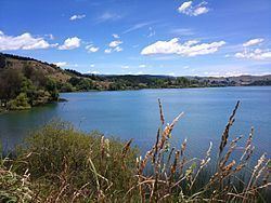
Lake Tūtira is a body of water in north-eastern Hawke's Bay in New Zealand. Much of the area was surveyed by Herbert Guthrie-Smith, who farmed 60,000 acres (240 km²) surrounding the lake. Guthrie-Smith, a naturalist, published the popular Tutira: the story of a New Zealand sheep station in 1921. Today, a camp is run at the site of his homestead.
Contents
Map of Lake Tutira, Tutira 4181, New Zealand
Sedimentary cores from the lake were used to demonstrate that the landslides mobilising sediments for transport into the lake occur in frequency and magnitude according to a power law.
Trout fishing is permitted as a stream flows into its northern reaches. For centuries Maori seasonally lived by Lake Tūtira and you can see the remains of six pa sites. The Tutira Walkway, ascends to the Table Mountain trig station for stunning views over Hawke's Bay and takes about five hours to complete.
The lake suffers from periodic algal blooms.
Geological history
The lake contains a high-resolution record of the sedimentation since its formation about 6,500 years ago. It has a small catchment area, whose dominant erosion mechanism is landsliding; as a result of this, infrequent, large storms account for the bulk of the sedimentary depositional volume; Cyclone Bola is a particularly important recent example.