
Length 14 km (8.7 mi) Elevation 1,724 m | States/Provinces Hawke's Bay | |
 | ||
Similar Kaimanawa Range, Ruahine Range, Cape Kidnappers, Te Mata Peak, Mangatutu Hot Springs | ||
Kaweka ranges sika hunting january 2017
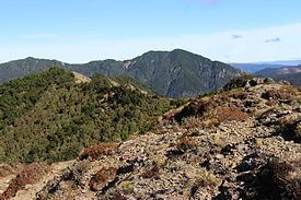
The Kaweka Range (also known as the Kaweka Ranges) of mountains is located in inland Hawke's Bay in the eastern North Island of New Zealand. It forms part of the mountainous spine of the North Island which runs from Wellington to East Cape, including the Tararua and Ruahine ranges.
Contents
- Kaweka ranges sika hunting january 2017
- Map of Kaweka Range Kaweka Forest Park 4179 New Zealand
- Sika spring hunt nz kaweka range 2016
- References
Map of Kaweka Range, Kaweka Forest Park 4179, New Zealand
The range lies between the city of Napier, 55 kilometres (34 mi) to the southeast, and Lake Taupo, 50 kilometres (31 mi) to the northwest. It is the source of many rivers which flow into Hawke Bay, including among them the Tutaekuri, Mohaka, and Ngaruroro Rivers.
The highest point in the range is Kaweka J (1,724 metres (5,656 ft)). The bush line varies from 1000 m to 1300 m.
A tramping track follows the ridge line of the entire range. The Kaweka challenge is a running race held annually in the range since 1990.