
Surface area 11.3 km (4.4 sq mi) Surface elevation 2,008 m Province West Nusa Tenggara | Basin countries Indonesia Max. depth 190 m (620 ft) Area 11.3 km² | |
 | ||
Water volume 36×10^ m (1.3×10^ cu ft) | ||
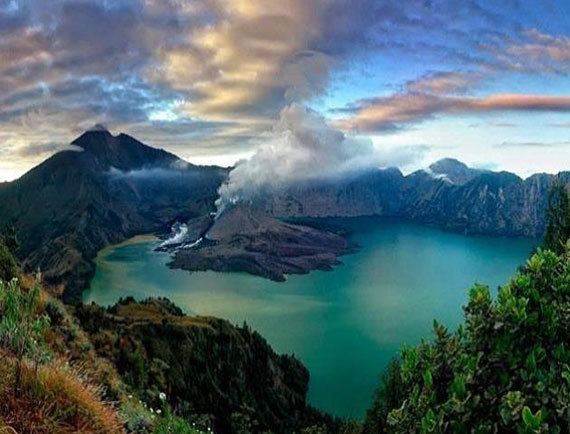
Segara Anak is a crater lake contained within Mount Rinjani on the island of Lombok in Indonesia. The name Segara Anak means child of the sea given to the blue colour of the lake reminiscent of the sea. The lake is heated, so its temperature is 20-22 °C, about 5-7 °C above the expected temperature for a lake in that altitude. At the west end of the lake is the volcanic cone Gunung Baru Jari, giving to the lake a crescent shape. Gas bubbles escape from the lake floor. The lake pH is 7-8.
Contents
Map of Danau Segara Anak, West Nusa Tenggara, Indonesia
Water surface of Segara Anak is 2,008 m above mean average sea level (MASL) as the highest caldera lake with an active volcano in the world, while the peak of Gunung Baru Jari is 2,376 m above MASL. Caldera lake area is 7.5x6.0 kilometer square with depth up to 230 meters.
Mount SamalasEdit
Lake Segara Anak is the remnant of a volcanic mountain named Mount Samalas, with an estimated height of 4200 metres. According to a 2013 study Mount Samalas erupted in 1257 AD, throwing as much as 10 cubic miles of rock into the atmosphere, and destroying the mountain. The eruption probably was a 7 on the Volcanic Explosivity Index, which would make it one of the largest eruptions of the last several thousand years. The eruption may have been the cause of anomalous weather in immediately following years, and may have even been a triggering factor for the Little Ice Age.