
Primary inflows Max. width 2 mi (3.2 km) Surface elevation 58 m Length 6.1 km | Max. length 3.8 mi (6.1 km) Area 15.09 km² Outflow location Quinault River | |
 | ||
Similar Lake Quinault Lodge, Lake Crescent, Ruby Beach, Hoh Rainforest, Hurricane Ridge | ||
Rain forest resort village at lake quinault washington a drivin vibin travel vlog
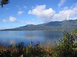
Lake Quinault (/kwᵻˈnɒlt/ or /kwᵻˈnɔːlt/) is a lake on the Olympic Peninsula in western Washington state. It is located in the glacial-carved Quinault Valley of the Quinault River, at the southern edge of Olympic National Park in the northwestern United States. One of the most dominant features of Lake Quinault is being located within the Quinault Rain Forest, a temperate rain forest.
Contents
- Rain forest resort village at lake quinault washington a drivin vibin travel vlog
- Map of Lake Quinault Washington USA
- Olympic peninsula washington usa lake quinault and rainforest
- References
Map of Lake Quinault, Washington, USA
Lake Quinault is owned by the Quinault Indian Nation. The area is accessible from U.S. Route 101.
Area activities include fishing (with permit from the Quinaults), scenic drives (a loop around the lake is longer than 30 miles (48 km)), and hiking. The southern side of the lake features a system of short hiking trails maintained by the U.S. Forest Service that are accessible to casual day hikers.
The southern side of the lake is home to the historic Lake Quinault Lodge and the Rain Forest Resort Village and is encompassed by the Olympic National Forest. The Quinault Loop Trail on the south side of the lake and the nearby Quinault Rain Forest Interpretive Trail connecting campgrounds, trails, and the lodge, with excellent temperate rainforest viewing. Each trail was designated a National Recreation Trail in 1979. The north side of the lake is bordered mainly by private homes and some small resorts located in Olympic National Park.
Lake Quinault receives an average of 332.92 centimeters (131.07 inches) of precipitation per year.