
Max. width 0.8 km (0.50 mi) Area 108 ha Surface elevation 33 m Width 800 m | Max. length 1.7 km (1.1 mi) Surface area 108 ha (270 acres) Length 1.7 km Mean depth 2 m | |
 | ||
Similar Yarndley's Bush, Sanctuary Mountain Maungatautari, Mount Pirongia, Kakepuku, Alexandra Redoubt | ||
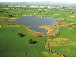
Lake Ngaroto is a peat lake in Waipa District of New Zealand.
Contents
Map of Lake Ngaroto, Te Awamutu 3883, New Zealand
Located 19 km south of Hamilton and 8 km north-west of Te Awamutu, it has a surface area of 108 ha, making it the largest of the Waipa peat lakes. The lake is hypertrophic, leading to eutrophication with corresponding poor water quality.
History
The Battle of Hingakaka was fought nearby, and the sacred carving Te Uenuku lost at this time. It was re-discovered in 1906, and now resides in the Te Awamutu Museum.
Recreation
References
Lake Ngaroto Wikipedia(Text) CC BY-SA