
Max. length 65 km (40 mi) Average depth 2 m (6 ft 7 in) Area 1,500 km² Width 20 km | Max. width 20 km (12 mi) Length 65 km Mean depth 2 m Settlement Kaputa | |
 | ||
Surface area 1,500 km (580 sq mi) (2005)dry (1916) | ||
Lake Mweru Wantipa or Mweru-wa-Ntipa meaning "muddy lake" (also called 'Mweru Marsh') is a lake and swamp system in the Northern Province of Zambia. It has been regarded in the past as something of mystery, displaying fluctuations in water level and salinity which were not entirely explained by variation in rainfall levels; it has been known to dry out almost completely. This is compounded by its remoteness and it not receiving the same attention from geographers and geologists as its larger and more accessible neighbours, Lake Tanganyika, 25 km east, and Lake Mweru, 40 km west, with which its name is sometimes confused.
Contents
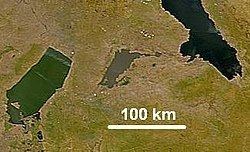
- Map of Lake Mweru Wantipa Zambia
- Lake extent
- Factors determining water level and salinity
- Settlements and roads
- References
Map of Lake Mweru Wantipa, Zambia
Lake Mweru Wantipa is a rift valley lake lying in a branch of the East African Rift, running from the Luapula River to Lake Tanganyika. There are some hot springs characteristics of a rift valley to the east. Its water is muddy in appearance, at times appearing reddish and 'slightly oily'. In the local dialect "wa ntipa" means "with mud", hence "Mweru Wantipa" distinguishes it from its bigger neighbour, Lake Mweru, which has clearer water.
Lake extent
Around 2005, Lake Mweru Wantipa's main north-east to south-west axis was about 65 km long and it was about 20 km wide, but a narrow branch extends roughly 30 km east from the northern end, giving a surface area of about 1500 km². In the south-east at Kampinda, a peninsula divides off a swampy inlet containing the Chimbwe Pools and a lagoon called Lake Cheshi. However at various times in the recent past it has been reported to be not a lake but a swamp with hardly any open water surface, and even to be a plain of dried out mud (littered with fish scales and bones, and the skeletons of dead crocodiles and hippos). These variations in open water surface occur not just within a single dry and rainy season cycle, but over years or decades. For instance it was reported as being a lake in 1890, 1897, 1911, 1919 and 1938, but a swamp in 1892, 1900–11, 1912–19, and 1922; and as having dried out around 1916. Its greatest depth has been reported as 5 m, but at times may be less than 1 m deep over most of its surface.
The salinity also shows long term variation, it was reported as being freshwater in 1929 and 1939, but saline in 1949.
Factors determining water level and salinity
While rainfall is the main factor, this may not be the complete story. Blockage of the Mofwe and of the rivers draining into Mweru Wantipa by papyrus and the growth of rushes may be part of the answer. It may also be that the effects of dry years may be delayed for a few years by the release of groundwater from surrounding hills into dambos which flow into the lake.
Settlements and roads
The main centre of population on the lake is the town of Kaputa, which also forms an administrative district of the Northern Province.
At one time the principal road serving the lake was the one from Mporokoso to its south-east shore where there was a ferry at Bulaya, but that has deteriorated and now the main highway is the one from Lake Mweru along the western and northern shores to Kaputa.