
Max. length c. 200 m (660 ft) Surface area 3.46 ha (9 acres) Area 3 ha | Max. width c. 55 m (180 ft) Surface elevation 2,240 m | |
 | ||
Primary outflows Mölsbach (Moels Stream) | ||
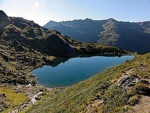
The Mölssee or Lake Moels can be found at the upper part of the Wattental valley at a height of 2,240 metres. With an area of 0.0346 km², it is one larger lakes in the area. The lake can be reached by following the Wattental Road beginning in Wattens. Then above the Moels Alp the lake may be gained by walking up a pretty steep trail heading for the Moels col (Mölser Scharte). The mountain lake lies within a military training area, so it can be only visited at certain particular times.
Contents
Map of Lake Moels, 6113, Austria
Water qualityEdit
The crystal-clear, clean, mountain lake water has a very high drinking water quality and is a habitat for fish such as carp and trout. The lake is very cold and, even in midsummer, temperatures of 16 °C are rarely reached.
Inflow and outflowEdit
The Mölsbach is the natural outflow and drains the lake and is one of the headstreams of the Wattenbach (Inn). It has a length of 4,35 kilometres and together with the Lizum stream it forms the Wattenbach at Walchen Camp.