
Primary outflows Calinawan River Max. length 29.10 km (18.08 mi) Surface elevation 42 m Mean depth 128 m | Primary inflows Area 173.4 km² Catchment area 870.7 km² Length 29.1 km | |
 | ||
Cities Surigao City, Jabonga, Butuan, Kitcharao, Alegria, Surigao del Norte, Mainit, Surigao del Norte | ||
Lake mainit our life our future cebuano narration
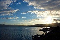
Lake Mainit is the fourth largest lake in the Philippines, having a surface area of 173.40 square kilometres (66.95 sq mi). The lake is also the deepest lake in the country with maximum depth reaching 223 metres (732 ft). It is located in the northeastern section of Mindanao and shared between the provinces of Surigao del Norte and Agusan del Norte.
Contents
- Lake mainit our life our future cebuano narration
- Map of Lake Mainit Philippines
- Etymology
- Plants
- Animals
- Municipalities bordering the lake
- References
Map of Lake Mainit, Philippines
Etymology
The name of the lake is a Visayan word mainit, which means "hot".
Plants
Animals
- Mindanao scops owl
- Mindanao savanna nightjar
- Mindanao Himalayan swiftlet
- Mindanao forest kingfisher
- White-breasted sea eagle (Haliaeetus leucogaster)
- Monkeys
- Wild pigs
- "Casili" (Anguilla spp.)
- Mudfish, "hayuan" or "halwan" (Channa striata)
- Gurami (Gourami belontiidae)
- "Bolinao" (Neosthethus thessa)
Municipalities bordering the lake
References
Lake Mainit Wikipedia(Text) CC BY-SA