
Type reservoir Surface area 22 acres (8.9 ha) Area 9 ha | Primary inflows Basin countries United States Surface elevation 241 m Water volume 420,600 m³ Inflow source Lagunitas Creek | |
 | ||
Catchment area 1.8 square miles (4.7 km) Similar | ||
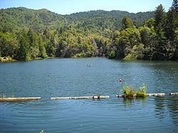
Lake Lagunitas is a reservoir on Lagunitas Creek in Marin County, California.
Contents
Map of Lake Lagunitas, California 94904, USA
Lake Lagunitas is one of seven reservoirs providing potable water to the Marin Municipal Water District. It is the oldest and smallest lake in the Mount Tamalpais watershed, with surface area of 22 acres (0.034 square miles or 8.9 hectares). About a mile east to Lake Lagunitas is Phoenix Lake, with surface area of approximately 25 acres. And 0.3 miles to the west of Lake Lagunitas is Bon Tempe Lake, which has an area of (a guess here) 280 acres. Further to the west of Bon Tempe Lake is Alpine Lake with an area of 224 acres.
The only major lake to the west of Fairfax-Bolinas Road is Kent Lake, the largest in the watershed with surface area of 432 acres.
Lagunitas DamEdit
The reservoir is impounded by Lagunitas Dam, an earth dam 48 feet (15 m) tall, 433 feet (132 m) long, and 12 feet (3.7 m) wide. The dam was completed in 1872.