
Primary inflows Catchment area 1,777 km (686 sq mi) Max. length 25 km (16 mi) Area 65.3 km² Length 25 km Inflow source Oglio | Primary outflows Oglio Surface area 65.3 km (25.2 sq mi) Surface elevation 185 m Outflow location Oglio | |
 | ||
Similar The Floating Piers, Val Camonica, Lake Garda, Lake Como, Val Trompia | ||
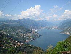
Lake Iseo or Lago d'Iseo [ˈlaːɡo diˈzeːo] or Sebino [seˈbiːno] is the fourth largest lake in Lombardy, Italy, fed by the Oglio river.
Contents
Map of Lake Iseo, Italy
It is in the north of the country in the Val Camonica area, near the cities of Brescia and Bergamo. The lake is almost equally divided between the Provinces of Bergamo and Brescia. Northern Italy is renowned for its heavily industrialised towns and in between there are several stunning lakes. Lake Iseo remains one of outstanding natural beauty, with its lush green mountains surrounding the crystal clear lake.
There are several medieval towns around the lake, the largest being Iseo and Sarnico. A notable tourism sector has emerged.
A road has been carved into the side of the mountains that travel to circumvent the entire lake.
In the middle of the lake is Monte Isola (or Montisola). There is easy access via the regular running lake ferries.
The Floating Piers, an art installation by Christo and Jeanne-Claude, was open to the public at Lake Iseo for 16 days in June and July 2016.
SettlementsEdit
Around the shore of the lake are some small towns:
Two smaller islands, Loreto and St. Paul, are privately owned.