
Primary inflows Official name Complejo Güija Area 45 km² Inflow source Ostúa River | Type Volcanic dam Surface area 45 km (17 sq mi) Designated December 16, 2010 Surface elevation 430 m | |
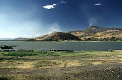 | ||
Lake Güija is a lake in Central America. The lake is situated on the border between Guatemala and El Salvador and has an area of 45 km², of which approximately 32 km² lies in El Salvador.
Contents
Map of Lago de Guija
The lake is of volcanic origin and was formed by a large basaltic lava flow from the San Diego volcano which blocked the Güija depression's original drainage. Lake Güija is fed by the Ostúa, Angue and Cusmapa rivers and is drained on its southeastern side by the río Desagüe, a tributary of the río Lempa. The lake is surrounded by the volcanic cones of the Mita, San Diego and Cerro Quemado. The Salvadoran side of the lake has several small isles: Teotipa, Cerro de Tule and Iguatepec, where a substantial number of pre-Columbian céramics have been discovered since excavations started in 1924. Bosque San Diego La Barra lies on the eastern side of the lake.
World Heritage Status
This site was added to the UNESCO World Heritage Tentative List on September 21, 1992 in the Mixed (Cultural + Natural) category.