
Lake type Endorheic Surface elevation 18 m Mean depth 3.2 m Width 2.1 km Inflow source Harnish Creek | Primary outflows none Max. length 5.8 km (3.6 mi) Area 7.8 km² Length 5.8 km Catchment area 320 km² | |
 | ||
Primary inflows | ||
Antarctic lake fryxell patterned ground
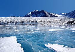
Lake Fryxell is a frozen lake 4.5 kilometres (2.8 mi) long, between Canada Glacier and Commonwealth Glaciers at the lower end of Taylor Valley in Victoria Land, Antarctica. Mapped by the British Antarctic Expedition under Robert Falcon Scott, 1910–13, the lake was visited by Professor T.L. Péwé during USN Operation Deep Freeze, 1957–58, who named it for Dr. Fritiof M. Fryxell, glacial geologist of Augustana College, Illinois.
Contents
- Antarctic lake fryxell patterned ground
- Map of Lake Fryxell Antarctica
- Blades on for lake fryxell
- References
Map of Lake Fryxell, Antarctica
Blades on for lake fryxell
References
Lake Fryxell Wikipedia(Text) CC BY-SA