
Type Ephemeral Max. length 100 km (62 mi) Surface area 5,714 km (2,206 sq mi) Area 5,714 km² | Basin countries Australia Max. width 30 km (19 mi) Surface elevation 439 m | |
 | ||
Location Goldfields-Esperance, Western Australia | ||
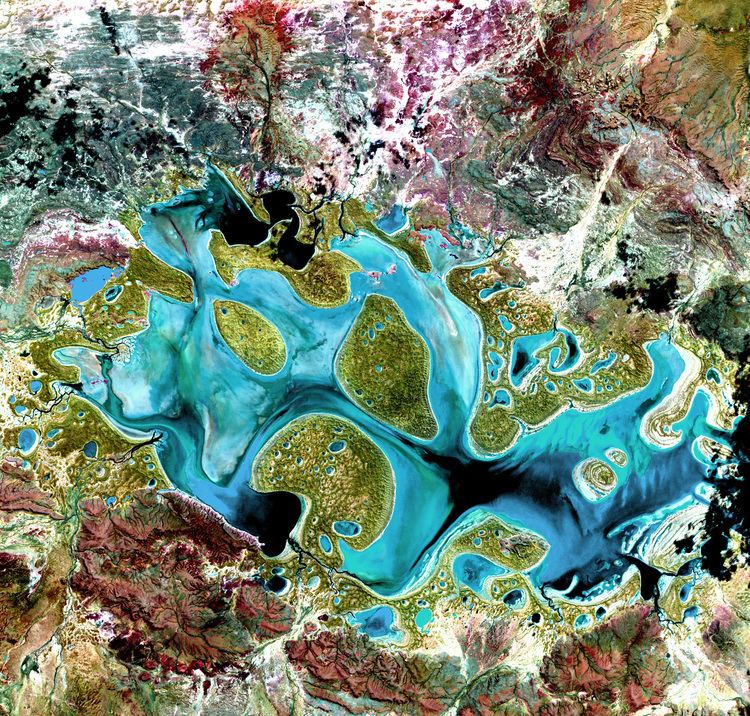
Lake Carnegie is a large ephemeral lake in the Shire of Wiluna in the Goldfields-Esperance region of Western Australia. The lake is named after David Carnegie, who explored much of inland Western Australia in the 1890s. A similar lake lies to its south east - Lake Wells.
Contents
Map of Lake Carnegie, WA 6646, Australia
Description
Lake Carnegie is predominately surrounded by desert environments.
It lies east of Wiluna and is at the southern edge of the Little Sandy Desert and south western border of the Gibson Desert. It is to the north-east of Leonora. It also lies to the north west of the Great Central Road and the Great Victoria Desert. It lies to the north of the main goldfields region of Western Australia.
The lake is approximately 100 kilometres (62 mi) in length and approximately 30 kilometres (19 mi) at its widest part. It has a total area of approximately 5,714 square kilometres (2,206 sq mi), making it one of the largest lakes in Australia. The surface elevation is 439 m (1,440 ft) above mean sea-level.
It fills with water only during very rare periods of significant rainfall, such as during the huge 1900 floods and in numerous recent tropical wet seasons when the monsoon and tropical cyclones have been moved south by recent climate change. In dry years, it is reduced to a muddy marsh.
In 1973 Tropical Cyclone Kerry crossed the north-west coast and moved south-west as far as the northern goldfields. Nearby pastoral leases such as Windidda Station received falls of 310 millimetres (12 in) and Prenti Downs received 209 millimetres (8 in) over a four-day period. The run-off was enormous, causing widespread flooding, with the Lake overflowing, leaving the area between Carnegie and Wiluna being described as "one huge lake".
Water entering the lake, unlike in more easterly playas of the Australian arid zone, does not come from well-defined river channels since the soils of the region are so weathered – lacking tectonic or glacial activity since the Carboniferous ice ages – that sediment is completely absent and the terrain so flat that only the most unweatherable rocks remain on the surface and well-defined river channels cannot form, especially since the extreme age of the soils and consequent high rooting density of native flora limits runoff to an extreme extent.
Pastoral leases
The lake area is bounded by Windidda, Yelma, Wongawel, Niminga, Carnegie and Prenti Downs pastoral leases, otherwise known in Western Australia as stations.