
Primary outflows None Max. length 7.7 km (4.8 mi) Area 14.6 km² Catchment area 543.4 km² Mean depth 50 cm | Basin countries Spain Max. width 2.8 km (1.7 mi) Surface elevation 995 m Length 7.7 km | |
 | ||
Primary inflows Cities | ||
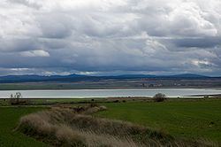
The Gallocanta Lake (Spanish: Laguna de Gallocanta) is an endorheic lake located just to the south of Gallocanta village, between the Aragonese comarcas of Campo de Daroca and Comarca del Jiloca, Aragon, Spain. This lake is situated on a high continental plain at an altitude of almost 1,000 m.
Contents
Map of Laguna de Gallocanta, Spain
It lies in a 53,600 ha natural basin known as El Campo de Bello, encircled by the Iberian System mountain ranges of Sierra de Santa Cruz and Sierra de Pardos in the north, Sierra Menera in the south and Sierra del Caldereros in the east. It is an intermittent rain-fed lake, largely dependent on abundant autumnal and spring rains if it is to maintain a sizeable amount of water into the hot summer months. During the summer of 1969 drought the lake dried completely, leaving a crust of salt and remaining dry for a long spell.
EcologyEdit
The Laguna de Gallocanta is one of the most important stopover sites for migrating common cranes in Spain, being able to give shelter to an average population of 20,000 birds at one time. The lake also holds a wide array of wetland birds when its water level permits, while its shores are visited by steppeland birds and raptors.
The Gallocanta Lake has been designated as a Special Protection Area and 6720 ha of the lake have been declared an Important Bird Area (IBA).