
Surface elevation 4,350 m | Surface area 10.9 km (4.2 sq mi) Area 10.9 km² | |
 | ||
Location | ||
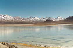
Laguna Blanca is a salt lake in an endorheic basin, in the Sur Lípez Province of the Potosí Department, Bolivia. It is near the Licancabur volcano.
Contents
Map of Laguna Blanca, Bolivia
Geography
The lake is at an elevation of 4,350 metres (14,270 ft) on the Altiplano. Its surface area is 10.9 km². The lake is 5.6 kilometres (3.5 mi) long and 3.5 kilometres (2.2 mi) wide.
The characteristic white colour of the water, that gave the lake its name, is caused by the high amount of minerals suspended in it.
Only a narrow corridor separates Laguna Blanca from the smaller Laguna Verde. Both are within the Eduardo Avaroa Andean Fauna National Reserve
References
Laguna Blanca (Bolivia) Wikipedia(Text) CC BY-SA