
Max. length 84 km (52 mi) Surface area 576 km (222 sq mi) Surface elevation 262 m Province Québec | Basin countries Canada Max. width 12 km (7.5 mi) Frozen November to June Area 576 km² | |
 | ||
Lacs des Loups Marins is a lake in the north of the province of Quebec in Canada. It is located about 150 km east of Hudson Bay and about 20 km northeast of Lac à l'Eau Claire.
Contents
Map of Lacs des Loups Marins, Baie-d'Hudson, QC, Canada
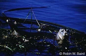
The name comes from its population of harbor seals (fr: loups marins or phoques). They belong to Phoca vitulina mellonae, the only seal subtype that lives year-round in fresh water.
History
The lake was known as Lower Seal Lake then Seal Lake until 1967 when it was named Lacs des Loups Marins. It was named after the seals that live on the shores and in the lake. The Cree called the lake Musiwaw Achikunipi (lake of seals in the tundra).
References
Lacs des Loups Marins Wikipedia(Text) CC BY-SA