
Surface area 0.028 km (0.011 sq mi) Area 3 ha | Surface elevation 1,066 m Catchment area 100 ha | |
 | ||
Similar Lac Vert, Gazon du Faing, Lac Noir, Lac Blanc, Col de la Schlucht | ||
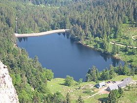
Lac des Truites is a lake in the municipality of Soultzeren (Haut-Rhin, France).
Contents
Map of Lac des Truites, 68140 Soultzeren, France
Geography
At an elevation of 1066 m, its surface area is 0.028 km². Is the highest lakes of the Vosges massif.
Toponimy
The name of the lake is a mistranslation of the German name Forlenweier. Frenchifying the toponyms of Alsace, the French authorities misread Forle as diminutive of Forelle (in French truite, in English trout) when in fact it is a diminutive of Föhre (pin, pine). The lake has various names, and on maps can be seen as Lac du Forlet.
References
Lac des Truites Wikipedia(Text) CC BY-SA