
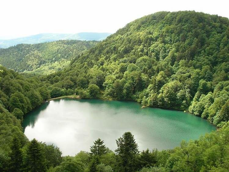
Max. depth 17 m (56 ft) Area 4 ha | Surface area 0.044 km (0.017 sq mi) Surface elevation 984 m | |
 | ||
Similar Baerenkopf, Tête des Perches, Gazon du Faing, Cascade du Nideck, Ballon d'Alsace | ||
Descente lac des perches
Lac des Perches is a lake in Haut-Rhin, France. At an elevation of 984 m, its surface area is 0.044 km². It is located on the Alsatian side of the Vosges Mountains in the municipality of Rimbach-près-Masevaux.
Contents
- Descente lac des perches
- Map of Lac des Perches 68290 Rimbach prC3A8s Masevaux France
- Toponymy
- History
- References
Map of Lac des Perches, 68290 Rimbach-pr%C3%A8s-Masevaux, France
Toponymy
The XIX century German name of the lake was Sternsee (lake of the star). This name came from an alteration of Ternsee ou Ternensee. Its French name comes from a misinterpretation of the patois toponym Lac des Bers (meaning straw), which was read into Bärsch (in German perch) and translated into the present-day name of the lake.
History
It is a Glacial Lake that was dammed in the 16th century to provide power to forges and to textile mills.
References
Lac des Perches Wikipedia(Text) CC BY-SA