
Elevation 2,013 m (6,604 ft) Population 3,623 (2005) | Area 129.4 km² Local time Friday 12:08 AM | |
 | ||
Time zone Central Standard Time (UTC-6) Weather 13°C, Wind N at 8 km/h, 73% Humidity | ||
La Manzanilla de La Paz is a town and municipality, in Jalisco in central-western Mexico. The municipality covers an area of 129.35 km². As of 2005, the municipality had a total population of 3623.
Contents
- Map of La Manzanilla de La Paz Jalisco Mexico
- Toponomy
- History
- Location
- Topography
- Hydrography
- Climate
- Flora and fauna
- Economy
- Tourism
- Festivals
- Government
- References
Map of La Manzanilla de La Paz, Jalisco, Mexico
Toponomy
According to tradition, the name comes from the abundance of hawthorn trees called manzanilla or apples, and "de la Paz" for being a peaceful people. Previously it was called San Miguel de las Flores.
History
Before the arrival of the Spanish, this region was inhabited by the Purépecha, within the Purépecha Empire. The conquest of the area was carried out in 1523 by, Alonso de Avalos who was sent by Hernán Cortés to conquer the West.
It was founded around the year 1882, when the inhabitants of the Guadalajarita, San Miguel de las Flores and El Rincon ranches agreed to form a congregation called La Manzanilla, being recognized as a precinct of the Tizapan el Alto municipality.
At the beginning of the century there was a cluster of brick and grass houses. With the surrounding ranches, it scarcely had 900 inhabitants. It belonged to the Canton of Sayula.
Its elevation to a municipality dates back to 1909, pursuant to Decree number 1307. Its first mayor was Irineo López. In La Manzanilla words of Purépecha origin remain, for example, while farmers in the rest of the state call the ears of corn that do not grow well "molonco" in La Manzanilla it is called "toquere". They call the ears of corn "toquera", the "chiquihuite" is known as "chihuite" and bag or backpack is called "quimil" or "chitara".
On January 1, 1969, by decree number 8452, the name was changed to la Manzanilla de la Paz.
Location
La Manzanilla de la Paz is located southeast of Jalisco. Its coordinates are 19°55'00" to 20°04'30" north latitude and 102º01'15" to 103º11'50" west longitude, at an altitude of 2013 meters above sea level.
The municipality is bordered on the north by the municipalities of Tuxcueca, Tizapan el Alto and the state of Michoacán on the east by the state of Michoacán and the Mazamitla municipality; on the south by the municipalities of Mazamitla and Concepción de Buenos Aires; on the west by the municipality of Concepción de Buenos Aires.
Topography
In general the surface is made up of flat areas (55%), there are also semi-flat areas (25%) and hilly areas (20%). Soils - The territory consists of land belonging to the Quaternary period. Soil composition is entirely of a Cambisol type. The municipality has a land area of 12,935 hectares, of which 5,800 are used for agriculture, 5,545 for livestock activity, 1430 are for forest use and 160 acres are urban lands. As far as property is concerned, an area of 10,343 hectares is private and 2,592 is state-owned. There is no communal property.
Hydrography
The Chiflón Dam belongs to the Central Pacific basin, La Passion-Tepalcatepec River subbasin.
Guadalajarita or
de la Pasión
La Peña
Las Cuevas
La Soledad
El Cerrito
Los Piratas
La Esperanza
El Tule and
Palo Verde
La Loma
Loma Alta
Sobinillas
Climate
The climate is semiarid, with dry winter and temperate with no well defined winter heat exchange. The average annual temperature is 19°C, maximum 25.1°C and minimum -05.8°C. Rainfall is recorded between the months of June through August, with an average rainfall of 1,011.2 millimeters. The average annual frost days is 55.7. Prevailing winds blow towards the south.
Flora and fauna
Vegetation is represented by wooded areas to the south, which is dominated by pine and oak species. Rabbit, squirrel, skunk, deer and birds inhabit the town.
Economy
Tourism
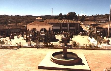
Main square.
Temple of San Miguel Arcangel.
Development of:
Napkins,
Tablecloths,
Towels,
Folders,
Embroidered dresses,
Coats and
Tissues.
Cerro La Pitaya.
Cerro López.
Sierra Del Tigre.
The Chiflón dam.
Palo Verde.
Festivals
Civil Festivals
Palenque and bullfighting. In Passover week
Religious festivities
Feast in honor of San Miguel. From 21 to 29 September.
Feast in honor of Santa Ana de Pascua. In March.
Holy Thursday and Friday.
Government
Its form of government is democratic and depends on the state and federal elections, held every 3 years, where the mayor and his cabinet is elected. The mayor is Rafael Alejandro Alvarez Espinoza, a member of PAN, which was elected in democratic elections held on July 5, 2009.