
Airport type Public Elevation AMSL 4,229 ft / 1,289 m Elevation 1,289 m | Owner City of La Junta 8/26 6,849 Phone +1 719-384-8407 | |
 | ||
Address 30267 1st Ave, La Junta, CO 81050, USA Similar La Junta Station, La Junta Golf Club, La Junta Animal Shelter, La Junta Electric Superinte, La Junta City Manager | ||
Landing at the la junta municipal airport in colorado
La Junta Municipal Airport (ICAO: KLHX, FAA LID: LHX) is a city owned, public use airport located three nautical miles (6 km) north of the central business district of La Junta, a city in Otero County, Colorado, United States. It is included in the National Plan of Integrated Airport Systems for 2011–2015, which categorized it as a general aviation facility.
Contents
Although many U.S. airports use the same three-letter location identifier for the FAA and IATA, this airport is assigned LHX by the FAA but has no designation from the IATA.
History
The history of La Junta Municipal Airport begins in 1935 with initial development by the Civil Aeronautics Authority. In 1940, the War Department leased the facility for civilian pilot training of British RAF and Royal Canadian Air Force pilots in 4-engine aircraft.
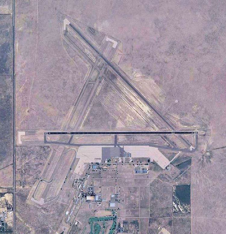
In 1942, the airport was taken over by the United States Army Air Forces and assigned to the Western Flying Training Command (WFTC) and the airfield was expanded to accommodate a large number of aircraft and training flights. Three asphalt runways were constructed in a triangle layout, 8000x150 (NE/SW), 8000x150 (E/W), 8000x150 (NW/SE) along with a large aircraft parking apron, taxiways, landing aids and several large aircraft hangars. In addition, four auxiliary airfields were constructed to accommodate training flights and emergency landings:
La Junta Army Airfield was activated on November 2, 1942 and was designated as an advanced twin-engine flying school under the jurisdiction of the 83d Flying Training Wing (Advanced, Twin-Engine), Douglas Army Airfield, Arizona. It operated B-25 Mitchell twin-engine bombers and Cessna AT-17, Curtiss AT-9 twin-engine, and BT-15 Valiant and BT-13 Valiant single-engined trainers.
In March 1944, the Advanced Twin Engine School was re-designated as the 402d Army Air Force Base Unit. In March 1945, the unit was re-designated as the 249th Army Air Forces Base Unit (Army Air Forces Pilot School, Specialized Four Engine) and jurisdiction was transferred to Second Air Force in June. The mission of La Junta AAF then became the training of replacement heavy bomber pilots in AT-17 Flying Fortress trainers for eventual assignment to B-17 Flying Fortress bombers.
The 50th and 358th Fighter groups were assigned to La Junta in late 1945 (August - November) for inactivation.
La Junta AAF received notice from Second Air Force that it would be inactivated on 28 February 1946 and it was returned to the local government for civil airport use following its closure.
More airport, city, and county history can obtained from the Otero Museum and the Otero County Historical Society.
La Junta Municipal Airport was used as a filming location for the 1973 film by Terrence Malick titled Badlands.
Facilities and aircraft
La Junta Municipal Airport covers an area of 4,200 acres (1,700 ha) at an elevation of 4,229 feet (1,289 m) above mean sea level. It has two runways: 8/26 is 6,849 by 75 feet (2,088 x 23 m) with an asphalt surface and 12/30 is 5,803 by 60 feet (1,769 x 18 m) with an asphalt/concrete surface. It also has one helipad designated H1 with an asphalt surface measuring 145 by 145 feet (44 x 44 m).
For the 12-month period ending December 31, 2010, the airport had 6,900 aircraft operations, an average of 18 per day: 95% general aviation and 5% military. At that time there were 15 single-engine aircraft based at this airport.