
Province Ontario | Country Canada | |
 | ||
Similar French River, Ontario Parks, Georgian Bay, Bridal Veil Falls, Spanish River | ||
La cloche mountains
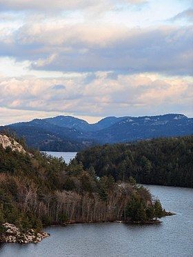
The La Cloche Mountains, also called the La Cloche Range, are a range of hills in Northern Ontario, along the northern shore of Lake Huron near Manitoulin Island. The hills are located in the Canadian Shield, and are composed primarily of white quartzite.
Contents
- La cloche mountains
- Map of La Cloche Mountains Sudbury Unorganized North Part ON Canada
- GeologyEdit
- HistoryEdit
- References
Map of La Cloche Mountains, Sudbury, Unorganized, North Part, ON, Canada
They extend roughly from La Cloche Provincial Park, south of Massey, to Killarney Provincial Park, southwest of Sudbury. The communities of West River, Willisville and Whitefish Falls are located directly within the range; the town of Espanola and the municipality of Killarney are located nearby, however they can be seen (from some vantage points) as far away as Manitoulin Island.
Ontario Highway 6 is the principal transportation route through the range.
Killarney Provincial Park is located in the range and is very popular among tourists. Another feature includes the "Heaven's Gate Trail" which traverses the length of the range from Willisville in the east to Massey in the west. Thought to be an old aboriginal trade route, it traverses the plateau of the range with the North Channel of Lake Huron visible to the south. The trail is particularly grueling and is rarely traversed mostly due to its length and remoteness from major cities.
La cloche mountains
GeologyEdit
With an estimated age of 3.5 billion years, the La Cloche Mountains are one of the oldest mountain ranges on Earth. The hills comprising the La Cloche Mountains are believed to have once been higher than today's Rocky Mountains. They remain among the highest altitudes in Ontario.
A southern extension of the La Cloche Mountains, the South La Cloche Mountains, extends to the south and juts into Georgian Bay along Badgeley Point, north of Killarney and Secondary Highway 637.
HistoryEdit
According to legend, the hills were warning bells, or tocsins, used by local First Nations for signaling. These "Bell Rocks" could be heard for a considerable distance when struck, and accordingly when voyageurs explored the area they named it with the French word for “bell” — La Cloche.