
Time zone EST (UTC−5) Area code(s) 450 and 579 Area 10.2 km² Province Québec | Constituted June 1, 1914 Postal code(s) J6N Population 2,307 (2011) Local time Wednesday 6:27 PM | |
 | ||
Weather -6°C, Wind W at 23 km/h, 83% Humidity RCMs Montérégie, Roussillon Regional County Municipality | ||
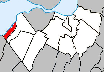
Léry is a small town situated along the south shore of Lake Saint-Louis in Quebec, Canada. The population as of the Canada 2011 Census was 2,307. Located on Route 132 west of Châteauguay and east of Beauharnois in the administrative region of Montérégie, the town is home to the Bellevue Golf Club, with its two 18-hole courses.
Map of L%C3%A9ry, QC, Canada
References
Léry, Quebec Wikipedia(Text) CC BY-SA