
Type Fortification | ||
 | ||
Similar Markovo Kale, Koznik, Forteresse de Mileševac, Zvečan Fortress, Vršac Castle | ||
Koprijan kurvingrad kod ni a
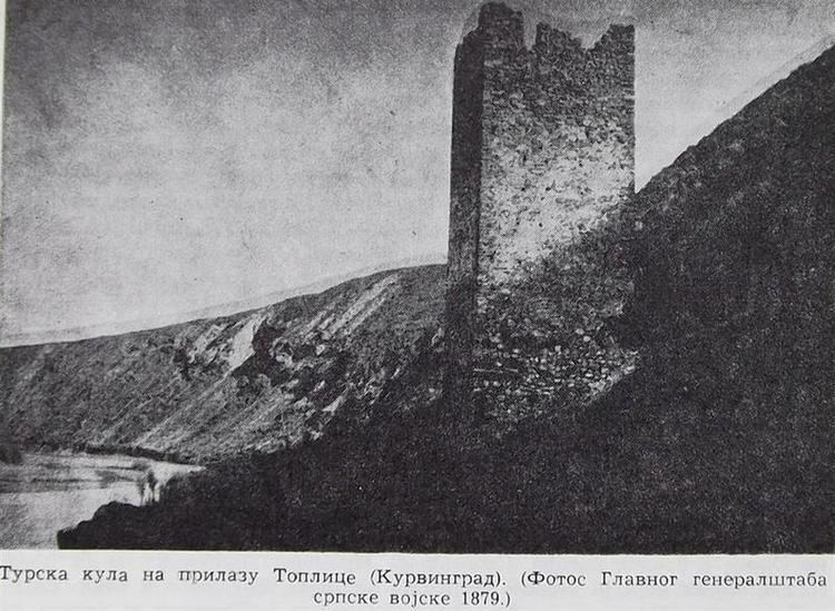
Kurvingrad (Serbian Cyrillic: Курвинград) (Whoretown) or Koprijan is the fortress which rises above the South Morava river, 11 km south of the town of Niš, respectively located in the village of Doljevac. It is assumed that this is the Medieval Koprijan, a town at the foot of the remains of a large settlement from the time of Antiquity, so that alone Citadel has millennium continuity of existence. Today, there are remains of fortifications, but they are not sufficiently studied.
Contents
- Koprijan kurvingrad kod ni a
- History
- 13721444
- 14451564
- Origin of the name
- Fort looks and features
- Kurvingrad today
- References
History
This location is not still sufficiently explored. Because of the transit and its strategic location, at the time of Roman Empire resort was the tower defense of the military road (Via Militaris). The city was an important military point at the time of the Byzantine Empire, with the name of Kompolos. The settlement left over from an earlier period of time was reconstructed, and has been named Koprijan ever since. Koprijan was a border city of the despots, which throughout its history repeatedly changed its owners, Serbian and Turkish. When was in the last fell swoop of Ottomans, Serbian medieval state was destroyed, Koprijan was completely demolished too. People were displaced and killed, some of them ending up as sex slaves in Asia Minor. The fortress was repeatedly used as building material for the construction of Niš Fortress. In the 20th century, materials from the ruins were used by the local population as building materials.
Emperor Justinian I in the mid-6th century in the vicinity of his home town, built thirty-two new forts and restored seven forts. He also built a number of castles, so that the population had a place of refuge in case of the barbarian attack on The Danube. It is said that the restored castle was ad Herculum i Calis. Calis later could have been incorrectly written Komplos. It is quite possible that the Byzantine village built on Kurvingrad was the northern defense for Justiinijane Prime.
Kurvingrad was, at the time of the battle for the Turkish throne in 1413. conquered and destroyed by the Sultan Musa Çelebi. City was after his defeat, returned to despot Stefan Lazarevic. Travel writer Ami Bue mentioned in the first half of the 19th century, the ruins of this city.
Document on Peace of Szeged in 1444. year. mentioning Koperhamum and Procopius, to us show that Komplos must have been on the site of the present Kurvingrad. There is a noticeable similarity in the names, and the whole area is rich in Byzantine findings. Thus, in the neighboring village of Doljevac were found a Byzantine basilica and several graves. During the digging the foundations of those buildings, people often found the ruins of older structures, which are dated to the 6th to 8th centuries by the materials used and the manner of building.
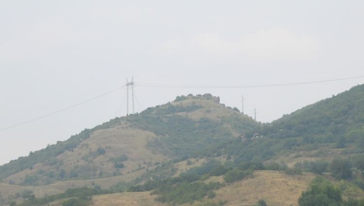
Komplos must have been an important highway connecting the South Morava and the Vardar river valleys, integral element of the network that was here in the past, important military point, which protected road from raiders and barbaric intrusion. What was the fate of the city at that time, it is not clear, but at the time it was regarded as impregnable. An important advantage of the city's defense was lying in inaccessible mountainous terrain, under which spanned clear view of the valley and the river, whose background was preserved by even higher mountain Seličevica. During World War I site Kurvingrad was used by the Germans command, for establishing their defensive front against the Serbian army, which was moving rapidly, advancing to the north, in October 1918. German front could not be held, despite its very strong position, only because the Serbian army came on top Seličevica and found themselves behinds enemies' back, who left Niš without a fight.
1372–1444
The old city fortification Koprijan was built at the time of Knez Lazar, on the foundations of the Roman and Byzantine fortification. The city that was surrounded with thick walls and towers, was raised by Vlastelin Nenad. Dimensions of the city are 80-50m, and in 1933, there was a church building in the city. The church built of stone, belonges to a Moravian type of construction.
In 1933, researchers found in the Niš Fortress a above the door-stone inscription for Koprijan (Whoretown-Kurvingrad) city. Item is now in the collection of the exhibits of the National Museum in Niš. The question is from where the panel was coming from? Stone was located next to the other stones, as well as other unused building materials. It is believed that the stone was got here in one of the latest Ottoman invasion, before the fall of Serbian despot. Koprijan shared his fate with most other Serbian medieval towns, who were robbed, burned and destroyed, and then used for the construction of other Turkish military bases. Dimension of the stone were 114 cm and 123 cm in length scale. Carved out of the white oval stone. The upper side of the stone is flat and the width of 26 cm, and the lower side of the back wall is 26 cm. On the pillar in the four row (width 16 cm) was written on the Serbian Church Slavonic, Cyrillic alphabet with the same letters in the size of 3 cm, the following: "Аз Ненад, син казнаца Богдана, сазидах си град Копријан годо...ва дни благовернаго господина ми кнеза лазара ва лето…"
Mentioned inscription was little damaged on the edges, so it is not very clear whether this year as preserved is the 6880 years, or it is 1372. years of the old Serbian calendar which coincides with the reign of Knez Lazar. If this is true, then in the 1372, Nenad the son of Bogdan, built the city of Koprijan. It is not known whether the medieval Koprijan is actually today Kurvingrad? Did the Byzantine fortress near Nis was Calis, and then incorrectly spelled as Komplos, it is uncertain, because at that place does not have found traces of Serbian medieval history. Unknown Byzantine fortress lost its significance in 1372. year., when was finished Koprijan city (Whoretown).
1445–1564
Ottoman Empire in 1451 were occupied the Whoretown, 70 years after the fall of Niš. The Ottoman population census in 1498 were mentioned Kurvingrad village with their 40 households. In 1516, Nišava District was affected by plague, which caused the population decline. In 1498th village of Kurvingrad has only 20 households.
Tabulation of the most important events on locality Kurvingrad.
Origin of the name
There are several legends about the origin of the name Whoretown. According to one legend, a certain immoral lady from the village, was during the fortress siege, coming out at night while people were sleeping, and opened the towns gate, in order for unseen entrance of the enemy.
According to another legend which is even more held among the people, in the town has lived a wealthy lady (maybe empress), which during the night was loved to visiting nearby Monastery of St. John at Orljane allegedly for prayer, right, but the truth is that she went there for some love of the priest. Legend has it that a girl was stretched canvas from the town to the church in which she was crossed at night time.
Village could occur in the time after the Ottoman invasion of the city surviving population. After the Ottoman conquest led to changes in the population, which now becomes predominantly Muslim. Name Whoretown or whore was accepted since the Ottoman invasion, when Koprijan were fell. The Ottoman Empire had a habit to give Serbian medieval cities a derogatory names, so it is considered that hows towns got his name. Also Whoretown can be read two ways in Ottoman's.
Also there is the belief that the name can be from the name of the Hungarian king Matthias Corvinus, but this claim is denied because there is not enough of historical evidence that Hungary then ruled this region.
Fort looks and features
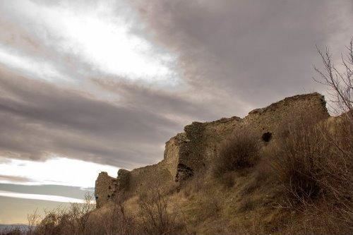
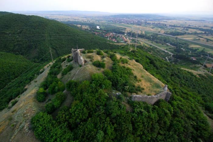
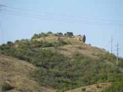
Whoretown village belonged to the oriental type of settlement and settlements in its vicinity, which are still remained identifying stamp of that time. The fort has an irregular square basis, dimension of 80 × 50 meters, with ramparts has reinforced towers, which surrounded the dry trench. The city was protected by the massive walls up to 10 m, and had a five towers. People entered through the gate which was reinforced by the tower, which is located near the northeastern crown. On the highest part of the hill, along the eastern rampart is located small town in which end is a tower, which rises above the main city gate. The city was protected on all sides by trenches. Because erosion trench today is 2 × 2 m, whereas in the past was deeper. The fortress ramparts, which is now an average height of 4 to 5 m, in the past, it was higher, but it can not be determined by how much exactly, because we have no surviving evidence. The city was built of gray-green undressed stone and the red Brick, which were there earlier, in the same place. Church Saint John was the ceremonial temple center. The western side of the city were kept by three city towers, of which preserved two towers are, one in the southwest, and one central tower. Today, the eastern wall was almost completely demolished. In the past, wall was consisting of two angular towers. As the regarding the three southern towers, only the central tower, and the south-west tower were left. Houses and their interiors was built of wood beam. Based on the foundations of the village's building, with the recess area of 12 m² and depth 1.5 m, while the height of the room today can not be determined. Researchers have found the former building, with dimensions of 12 m², with 1.5 m in depth, while the height of the room today can not be determined. It is believed that this was probably the cistern. A cistern this big could provide enough water for 1,000 people during the siege, but the question is how the water is brought into the city. This raises the assumption that the city owned his own complex of underwater Channel which led to the river South Morava. In the village below the fort were found, during archaeological excavations in year 1933, the foundations of the church built in the Moravian style. The floor of the church was from rough mosaic, The floor of the church was from rough mosaic, and the other parts is derived from alternating tiles, white marble, and green stones, with dimensions 20 x 20m.
Kurvingrad today
Today the ruins stay in a ruined condition. For many years in the past, residents of surrounding villages are destroying the remains of the fort, and use its stones, in large quantities, for building their own homes, which today left their mark on ruins. By the Decision the republic's Institute for Protection of Cultural Monuments, in November 1947., this historical monument has got a status of general people's cultural property, and placed under the protection of the state, along with its surrounding.
Of well-preserved forts parts, today are north and east rampart with towers. Western rampart does not exist, while on the south side, all that's left is little remains of the surviving tower in this area. Rampart Little City is barely discernible, and all what left from the "Donzon tower" is a larger pile of stones. The main city gates is destroyed, while tower which protecting main gate is preserved in fragments. Within the Small Town were found the remains of a square building that was probably used as a cistern, while around town people can see the remains of dried Trench.