
Source Gorski kotar Bridges Drežnik Viaduct | Length 297 km | |
 | ||
Main source Razloge, Gorski kotar, Croatia313 metres (1,027 ft) Basin size 10,032 km (3,873 sq mi) Discharge Average rate:283 m/s (10,000 cu ft/s) Similar Korana, Sava, Mur, Una, Krka | ||
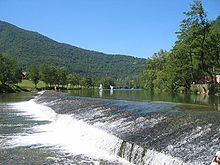
The Kupa (Croatian) or Kolpa (Slovene, from Latin: Colapis in Roman times) river, a right tributary of the Sava, forms a natural border between north-west Croatia and southeast Slovenia. It is 297 kilometres (185 miles) long, with its border part having a length of 118 km (73 mi) and the rest located in Croatia.
Contents
Map of Kupa
CourseEdit
The Kupa originates in Croatia in the mountainous region of Gorski Kotar, northeast of Rijeka, in the area of Risnjak National Park. It flows a few kilometers eastwards, receives the small Čabranka River from the left, before reaching the Slovenian border.
It then continues eastwards between the White Carniola region in the north and Central Croatia in the south. The Kupa receives influx from the river Lahinja from the left in Primostek, passes Vrbovsko, and eventually detaches from the Slovenian border having passed Metlika.
It then reaches the city of Karlovac, where it receives influx from two other rivers from the right, Dobra and Korana (which in turn is joined by Mrežnica). The Kupa continues flowing to the east, where it merges with Glina from the right as well as Odra from the left, and proceeds to the town of Sisak where it flows into the Sava River.
PollutionEdit
Fairly unpolluted downstream to Karlovac, the upper Kupa is a popular place for bathing in summer. The section from Stari Trg down to Fučkovci since 2006 is part of the Slovenian Krajinski park Kolpa nature reserve.
The hydrological parameters of the Kupa are regularly monitored at Radenci, Kamanje, Karlovac and Jamnička Kiselica.