
Elevation 625 m | ||
 | ||
Similar Western Ghats, Amba Ghat, Kolkewadi Dam, Koyna Dam, Tamhini Ghat | ||
Kumbharli ghat
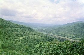
The Kumbharli Ghat is a mountain pass in Maharashtra, India that connects the coastal Ratnagiri District in Konkan region of Maharashtra with the Satara District in Desh region. It cuts across the Western Ghats range. It is one of few link roads between the Konkan and Ghatmaatha in Maharashtra. The road, a state highway, is at an average elevation of 625 m (2,051 ft). It links the cities of Chiplun (Ratnagiri district) and Karad (Satara district). Near the eastern end is the Koyna Dam.
Contents
- Kumbharli ghat
- Map of Kumbharli Ghat Akuskhan Nagar Maharashtra 415601
- Kumbharli ghat avi
- Location
- References
Map of Kumbharli Ghat, Akuskhan Nagar, Maharashtra 415601
Kumbharli ghat avi
Location
This ghat is on the Karad-Chiplun state highway. Also, this highway joins to the NH-4 near Umbraj. Malharpeth, Patan and Koyananagar are the major cities on this road.
References
Kumbharli Ghat Wikipedia(Text) CC BY-SA