
PIN 761131 | Time zone IST (UTC+5:30) | |
 | ||
Kulada is a small village located near Bhanjanagar of Ganjam district in Orissa. It is located 108 km towards North from District Headquarters Chhatrapur. 159 km from State capital Bhubaneswar. Asika, Hinjilicut, Phulabani, Berhampur are the nearby Cities to Kulada. Oriya is the Local Language here.
Contents
Map of Kulada, Odisha 761131
Geography
It is situated to the north west of Ganjam District with a ruin fort, river Mahanadi flowing in the east and dense forest in the west side of the ruined fort. Bhanjanagar, Brahmapur etc. are the nearest towns / cities to Kulada village. It is surrounded by Belaguntha Tehsil towards East, Surada Tehsil towards South.
Demography
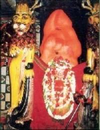
Legend speaks that during 12th century a Bhanja ruler had joined hands with a tribal leader’ KULA’ to be eradicating the foreign invasion. Seeing the danger from the tribe he stained the tribal leader KULA and on the same place, constructed a fort which was later known as Kulad / Kullargad. The original temple is at the top of the hill known as Upper Bagh Devi with 210 steps. Upendra Bhanja spent his term in meditation at this place.
Transportation
There is no railway station at Kulada. Berhampur is the nearest railway station located 90 km from State Capital Bhubaneswar.
Festival
Kulada is famous for Goddess Bagh Devi which is the presiding deity, Kulad is said to be birthplace of great Oriya Poet Kabi Samrat Upendra Bhanja. As the steps are yet to be made and the route is very tough for climbing another temple of Goddess Bagh Devi has been constructed near the road where people in large number gather to worship. Kulad has many other temples also. The other important temples of Kulad are Temple of Lord Jagannath, Mausimaa temple, Ratneswar Mahadev temple etc. Sankranti day of every month. Thakurani Yatra every three years. Rathyatra and Dola Purnima, Dashahara (4 days) and Ashoka Ashtami are the main festival observed in the village of Kulada