
Urban okrug Kudymkar Urban Okrug Local time Saturday 11:42 PM | Area 25.3 km² | |
 | ||
Administratively subordinated to town of krai significance of Kudymkar Administrative center of Komi-Permyak Okrug, Kudymkarsky District, town of krai significance of Kudymkar Weather -2°C, Wind S at 11 km/h, 52% Humidity | ||
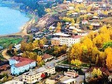
Kudymkar (Russian: Куды́мкар; Komi: Кудымкöр) is a town and the administrative center of Komi-Permyak Okrug of Perm Krai, Russia. Until 2005, it was the administrative center of Komi-Permyak Autonomous Okrug, a federal subject of Russia. It is located on the Inva River and on the left bank of its tributary the Kuva; 201 kilometers (125 mi) from Perm by road. Population: 28,967 (2010 Census).
Contents
- Map of Kudymkar Permskiy Kray Russia
- History
- Administrative and municipal status
- Economy
- Demographics
- References
Map of Kudymkar, Permskiy Kray, Russia
History
It was first mentioned in 1579. In 1931, it was granted urban-type settlement status. In 1938, town status was granted.
Administrative and municipal status
Within the framework of administrative divisions, Kudymkar serves as the administrative center of Komi-Permyak Okrug, an administrative unit with special status within Perm Krai, and of Kudymkarsky District, even though it is not a part of it. As an administrative division, it is incorporated separately as the town of krai significance of Kudymkar—an administrative unit with the status equal to that of the districts. As a municipal division, the town of krai significance of Kudymkar is incorporated as Kudymkar Urban Okrug.
Economy
Most important companies are OAO "Moloko" (dairy products) and OAO "Myasokombinat" (meat products). There are also some other food industry companies.
Demographics
As of the 2002 Census, 64% of population were Komi-Permyak people; 33% were Russians.
Historical population of Kudymkar: