
Country Thailand Time zone ICT (UTC+7) Vehicle registration กระบี่ Population 456,811 (2014) Area rank Provinces of Thailand | Capital Krabi ISO 3166 code TH-81 Area 4,709 km² Area code 075 | |
 | ||
Points of interest Phi Phi Islands, Railay Beach, Ko Poda, Khao Phanom Bencha N, Ko Lanta Yai Destinations Ao Nang, Ko Phi Phi Don, Ko Lanta Yai, Mu Ko Lanta National, Than Bok Khorani National | ||
Crystal lagoon crystal pool or pond in krabi province southern thailand
Krabi (Thai: กระบี่, [krā.bìː]) is one of the southern provinces (changwat) of Thailand, on the shore of the Strait of Malacca. Neighbouring provinces are (from north clockwise) Phang Nga, Surat Thani, Nakhon Si Thammarat, and Trang. Phuket Province lies to the west across Phang Nga Bay. Krabi town is the seat of provincial government.
Contents
- Crystal lagoon crystal pool or pond in krabi province southern thailand
- Map of Krabi Thailand
- History
- Geography
- Environment
- Projected impact of changes in climate
- Population and culture
- Symbols
- Administrative divisions
- References
Map of Krabi, Thailand
History
Circa 1200 CE, Krabi was tributary to the Kingdom of Ligor, a city on the Kra Peninsula's east coast, better known today as Nakhon Si Thammarat. In modern times, Krabi was administered from Nakhon Si Thammarat, even after 1872 when King Chulalongkorn granted Krabi town status. In 1875 it was made a direct subordinate of Bangkok, becoming what is now a province. In 1900 the governor moved the seat of the province from Ban Talad Kao to its present location at the mouth of the Krabi River.
It is believed the town may have taken its name from the word "krabi", which means "sword". This may stem from a legend that an ancient sword was unearthed prior to the city's founding.
Geography
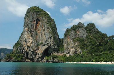
The province is on the Strait of Malacca and is noted for its natural beauty. There are solitary limestone peaks, both on land and in the sea. Rock climbers from all over travel to Ton Sai Beach and Railay Beach. The beaches form part of Krabi's Phra Nang Peninsula. Of the 154 islands in the province, Ko Phi Phi Leh is the most famous, as it was the site of the movie The Beach. Other notable islands include Ko Phi Phi Don, part of the Phi Phi Islands, and Ko Lanta, a larger island to the south. The coast was damaged by the tsunami of 26 December 2004.
Krabi's limestone hills contain many caves, most having stalactites and stalagmites. Tham Chao Le and Tham Phi Hua To, both in Ao Luek District, contain prehistoric rock-paintings depicting humans, animals, and geometrical shapes. In Lang Rong Rien cave in 1986 archaeologists found 40,000-year-old human artifacts: stone tools, pottery, and bones. It is one of the oldest traces of human occupation in Southeast Asia. Krabi's caves are one of the main sources of nests of the edible-nest swiftlet, used in the making of bird's nest soup.
Krabi's farmland is dominated by a duopoly of rubber and palm oil plantations. Palm plantations alone occupy 980,000 rai (1,568 km2), or 52 percent of the province's farmland. Together, palm oil and rubber cover 95 percent of Krabi's cultivated area with many smallholder farms amidst industrial plantations.
Environment
In mid-2015, government plans to build an 800 megawatt coal-fired electricity generating station (EGAT Coal-Fired TH #3) in Tambon Pakasai in Amphoe Nuea Khlong have generated protests and hunger strikes by those opposed to the plant who say that it would endanger Krabi's relatively pristine environment. The Electricity Generating Authority of Thailand (EGAT) has pushed forward with development. The government intends to start the bidding process without an environmental assessment in order to "save time". The Krabi site is one of nine coal-fired plants planned for southern Thailand to be constructed over the next two decades to off-set the depletion of natural gas fields in the Gulf of Thailand. Opponents of the plan say their demands—which include a three-year waiting period to see if the province can produce 100 percent renewable energy—have been ignored.
Thailand's resolve to go ahead with the massive new coal-fired power station in Krabi, a 315 MWe, 48 billion baht undertaking, presents a problem. Coal is a major source of mercury poisoning and has been found in toxic amounts up to 12 times more than the maximum acceptable dose in the inhabitants of Tha Thum in Prachinburi Province. Possible vectors are fly ash from the local coal power plant, coal dust from outdoor coal storage piles, or coal ash, used as fertiliser. These present risks to Krabi. Coal pollution mitigation technology, sometimes called "clean coal", is still in its infancy and at the moment can only handle sulphur dioxide, nitrogen oxides, and particulates. Carbon dioxide sequestering is much more complex and costly. Two academics, referring to coal pollution mitigation in general, point out that, "So-called 'clean coal' is expensive, untested, unwieldy and unworkable, yet it is raised as a panacea."
In mid-2016, a pro-renewables working group in Krabi published a "Green Power Development Plan". It concludes that Krabi Province can depend on renewables—mainly biomass and biogas—for 100 percent of its electricity needs. The report calculates that biomass could generate 118 MW in an initial three-year period; solar could generate 55 MW; biogas, 54 MW; and wind energy 40 MW. During a subsequent three-year period, renewables could generate 287 MW, exceeding the province's peak demand year of 2015, when it consumed 143 MW. If adopted, the plan would obviate the need to import coal, saving 175 billion baht over a 25 year period.
In August 2016, EGAT solicited bids for the plant's construction and received bids in the range of 32-34.9 billion baht. The bidding process and the environmental and health impact assessment report were completed simultaneously. "After being delayed for almost two years, this November [2016] will be the time to decide whether to proceed or scrap the plan," said Energy Minister Gen Anantaporn Kanjanarat.
Projected impact of changes in climate
In a 2008 study of the impact of climate change on Krabi Province to the year 2033, the following effects were projected:
Population and culture
Krabi's population includes Buddhists, Thai-Chinese, Moken (sea gypsies), and Muslims. Population is most dense in the coastal area in Nuea Khlong District and Krabi city districts, both with population densities above 150 people per km2. The least densely populated area is the inland mountain Khao Phanom District at 61 persons per km2. Buddhism is the religion most observed (66 percent) followed by Muslim (33 percent). Krabi has been little affected by the Muslim militant insurgency that has plagued the southern provinces of Thailand since 2003. Traditionally Krabi's inhabitants worked in agriculture, for the province is rich in rubber, palm oil, and oranges. In recent years tourism has become an important source of income.
Symbols
The seal of the province shows two ancient crossed swords ("krabi" is the word for an ancient Siamese sword) in front of the Indian Ocean and Khao Phanom Bencha mountain which, at 1,397 metres (4,580 ft) above sea level, is the highest mountain of the province.
The provincial slogan is, "Krabi, the liveable city, friendly people."
The provincial tree is the thung-fa (Thai: ทุ้งฟ้า) or Alstonia macrophylla.
Administrative divisions
Krabi is subdivided into eight districts (amphoe), which are further divided into 53 communes (tambon) and 374 villages (muban).