
Max length 7.5 km | ||
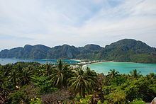 | ||
Points of interest Phi Phi Viewpoint 2, Ko Phi Phi, Phi Phi Andaman Legacy R, Phak Nam Bay, Phi phi island | ||
Ko Phi Phi Don (Thai: เกาะพีพีดอน, rtgs: Ko Phiphi Don, [kɔ̀ʔ pʰīː.pʰīː dɔ̄ːn]) is the largest of the islands in the Ko Phi Phi archipelago, in Thailand. The islands are administratively part of Krabi Province. It is the only island in the group with permanent inhabitants.
Contents
- Map of Ko Phi Phi Don Ao Nang Mueang Krabi District Krabi Thailand
- Villages
- Tourism
- Ecology
- Tsunami
- References
Map of Ko Phi Phi Don, Ao Nang, Mueang Krabi District, Krabi, Thailand
Like the other islands in the archipelago, Phi Phi Don is a non-volcanic island largely made of limestone. It is almost separated into two islands, but a strand of flat land connects them. On this strand lies the largest town on the island, as well as most of the resorts.
Villages
Tourism
Phi Phi Don is now squarely on the tourist map, and tourists from all over the world (especially Europe, Japan, China and the wealthier Southeast Asian countries, e.g., Singapore and Malaysia) flock to the island. Accessible from Phuket and mainland Krabi Province, all tourists must arrive by ferry. (The trip from Phuket takes around 90 minutes.) This has essentially turned the island into a rush of day trippers who overpopulate the island from 11:00-15:00. The island still holds much charm that can be enjoyed in the hours that the flocks from Phuket are not there. While in former times, Phi Phi Don was a serene paradise, parts of it (especially the Ton Sai Bay area) have been exploited for tourism. Restaurants, shops, internet cafes, and shanty towns abound.
Ecology
While much of the island is a so-called "marine reserve", not much is being done about the rampant growth on the island and destruction of the reefs. Also, litter (usually in the form of cans and plastic bags) is strewn all over certain areas of popular beaches (usually near the shanty towns). Much of the litter is not from tourists, but from the locals. However, since Phi Phi Don is popular for diving and snorkeling, the locals have done away with dynamite fishing and other harmful activities that had probably threatened the reef even more than tourism.
Though in need of much greater conservation efforts, Phi Phi Don is still a spectacular island in its own right. Featuring limestone cliffs abounding with vegetation, a look-out point, and clear waters, this island will probably stay on the tourist map as long as development becomes more in tune with nature.
Tsunami
More than 1,000 people died 26 December 2004 when a tsunami struck this island.
Lohdalum Bay was hit the hardest, with the majority of the bungalows and restaurants along the beach destroyed. There is a memorial for those killed in the tsunami on the beach facing Lohdalum Bay. Every year there is a small memorial service where family members and friends come to pay their respects and talk about those they lost. A moment of silence is observed at the time the tsunami hit.
There were three waves: the first one flooded Lohdalum Bay, the second destroyed all of the wooden buildings and the third and largest ruined stone buildings as if they were made of sand. The whole tsunami lasted for only three minutes (from 10:29–10:32) but it nearly destroyed the whole island.
Many organisations have supported Phi Phi. These include the Government of Japan supporting the local hospital and Round Square supporting the local school.