
Time zone CET/CEST (UTC+1/+2) Area 4.48 km² | Elevation 235 m (771 ft) Postal codes 52076 Postal code 52076 | |
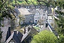 | ||
Kornelimünster is a town in the rural Münsterländchen area of Kornelimünster/Walheim, a district of Aachen, Germany.
Contents
- Map of KornelimC3BCnster 52076 Aachen Germany
- History
- Mayors
- Traffic
- Notable persons
- Nearby towns
- Regular events
- Works cited
- References
Map of Kornelim%C3%BCnster, 52076 Aachen, Germany
History
The Kornelimünster Abbey was founded in 814 on the Inde River by Benedict of Aniane (750–821), at the suggestion of Louis the Pious, son and successor of Charlemagne. The cloister was originally called Redeemer Cloister on the Inde (Erlöserkloster an der Inde).
In the middle of the 9th century, the cloister was given imperial immediacy and subsequently came into possession of a large swath of area surrounding the church.
In 875, certain reliquaries were exchanged for one belonging to the martyr saint, Pope Cornelius (who died in 253). The cloister thereafter became known as Sancti Cornelii ad Indam (St Cornelius on the Inde), and then Kornelimünster. Today, the official title of the abbey is the Abbey of St Benedict of Aniane and Pope Cornelius.
In 1500 the abbey became part of the Lower Rhenish–Westphalian Circle, and in 1802, the area fell to the French. Along with other abbeys in French controlled areas, the abbey at Kornelimünster was abolished and the monks were forced to leave. During this time, the community of Kornelimünster came under administration of the French, under the Mairie system. In 1815 Prussia came into possession of Kornelimünster and was subsequently administered as part of the old district of Aachen (before the administrative restructuring of 1972). Benedictine monks returned to the Kornelimünster Abbey in 1906 to found the New Benedictine Kornelimünster Abbey. The St Cornelius Church of the former abbey is today the parish church of the community and is the oldest abbey building still used in the state of North Rhine-Westphalia.
During World War II U.S. forces reached the area south of Aachen in the fall of 1944. On 19 September Kornelimünster was captured without major damage. The first summary court in Germany during World War II opened in Kornelimünster late in September.
In 1971 Kornelimünster joined together with other area communities such as Breinig, Mulartshütte, Roetgen, Venwegen and Walheim to argue in favor of creating a Münsterland district. Instead, on 1 January 1972, the area was divided as follows: the Kornelimünster and Walheim communities were combined into the Kornelimünster/Walheim district of Aachen, while Breinig and Venwegen went to Stolberg. The remaining communities of Mulartshütte, Rott and Roetgen were combined into the Roetgen district.
Mayors
Traffic
Kornelimünster no longer lies along the Bundesstraße 258, which connected Aachen to the Eifel. The nearest onramp of the Autobahn 44 (E40) is in Brand, another district of Aachen. Kornelimünster is, however, reachable by bicycle along the Vennbahn bike path.