
Admin. region Stuttgart Elevation 183 m (600 ft) Local time Friday 1:53 PM Postal code 74399 | District Ludwigsburg Time zone CET/CEST (UTC+1/+2) Population 2,982 (31 Dec 2008) | |
 | ||
Weather 12°C, Wind NW at 13 km/h, 55% Humidity | ||
Walheim is a town in the district of Ludwigsburg, Baden-Württemberg, Germany with a considerable viticulture. Besides the village Walheim there are no other places belonging to the municipal area of Walheim.
Contents
- Map of Walheim Germany
- Geography and climate
- Historical geography
- History
- Economy and infrastructure
- References
Map of Walheim, Germany
Geography and climate
Walheim is situated in a height of 171 to 260 meters between the Neckar and the vineyards. The annual average temperature is 9.5 °C (49 °F) and the annual rainfall amounts to 700 l/m². Due to the mild climate the Walheim forest does not feature naturally located conifers, but mixed forest with a fairly big amount of oaks.
Historical geography
The abandoned village Dambach is situated in the municipal area of Walheim.
History
Already in the Neolithic Age around 4000 to 2500 BC the area of Walheim was populated. A female skeleton found in 1980 has been dated to 1500 BC and therefore belongs to the Bronze Age. Starting 450 BC Celtic defense and living facilities have been built.
Lots of vestiges of the Romans can be found in Walheim: There are remnants of two Roman castra and a vast civil settlement. During the period of 85 to 120 AC the area of Walheim was an important emporium.
As from 233 AC the Alamanni began to settle the territory and in 496 AC the region became Franconian.
Economy and infrastructure
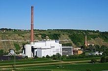
Walheim is a town with a significant viticulture. Close by the town the Walheim power plant is located.