
Length 650 km (400 mi) Elevation 3,211 m | Country Iran | |
 | ||
Similar Nisa - Turkmenistan, Alborz, Karakum Canal, Köpetdag Stadium, Geok Tepe | ||
The Kopet Dag, Kopet Dagh, or Koppeh Dagh (Persian: کپهداغ; Turkmen: Köpetdag), also known as the Turkmen-Khorasan Mountain Range is a mountain range on the frontier between Turkmenistan and Iran that extends about 650 kilometres (400 mi) along the border southeast of the Caspian Sea, stretching northwest-southeast from near the Caspian Sea in the northwest to the Harirud River in the southeast. The highest peak of the range in Turkmenistan is southwest of the capital Ashgabat and stands at 2,940 metres (9,646 ft). The highest Iranian summit is Mount Quchan (Kuh-e Quchan) with 3,191 metres (10,469 ft).
Contents
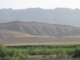
Map of Kopet Dag, Iran
Etymology
The word "kopet" or in Persian "koppeh" means "pile" or "heap", and the word "dag" or "dagh" means "mountain" in Turkish. So "Kopet Dagh" or "Koppeh Dagh" could be defined as "the mountain that is piled or heaped" and therefore the words could mean "piled or hilly mountains" or "low hills" in general.
Geology
Geologically, the Kopet Dag Range is made chiefly of Lower Cretaceous sedimentary rocks with a smaller portion of Jurassic rocks in the southeastern parts. The mountains were formed in the Miocene and the Pliocene during the Alpine orogeny. As the Tethys Sea was closed and the Arabian Plate collided with the Iranian Plate and was pushed against it and with the clockwise movement of the Eurasian Plate towards the Iranian Plate and their final collision, the Iranian Plate was pressed against the Turan Platform. This collision folded the entire rocks that had been deposited in this geosyncline or basin from the Jurassic to the Miocene and formed the Kopet Dag Mountains.
Topography
The Kopet Dag Range is a region characterized by foothills, dry and sandy slopes, mountain plateaus, and steep ravines. The Kopet Dag is undergoing tectonic transformation, and is subject to severe earthquakes. Earthquakes exceeding seven on the Richter scale have been recorded.
The most western foothills of the Kopetdag mountains are known as the 'Kyurendag Ridge'.
Archaeology
The foothills of the Kopet-Dag near Ashgabat are the site of the remains of the ancient Parthian city of Nisa (Nessa, Nusaý).
Ski resort
This mountain range has a ski resort, officially opened by the former president of Turkmenistan, Saparmurat Niyazov. Despite the lack of snow in the Kopet Dag mountains, Niyazov was determined to build a major resort there.
Plants and animals
The woodlands of the region are home to many fruit trees, shrubs, and vines that have proved valuable for human use and selective breeding, including pomegranate (Punica granatum), wild grapes Vitis sylvestris, fig (Ficus carica), wild apple (Malus turkmenorum), wild pear (Pyrus boissieriana), wild cherries (Prunus spp., also called Cerasus microcarpa, C. erythrocarpa, C. blinovskii), wild prune (Prunus divaricata), almonds (Amygdalus communis=Prunus dulcis, and A. scoparia=Prunus scoparia), and hawthorns (Crataegus spp.).