
Borough Feijenoord district | Time zone CET (UTC+1) | |
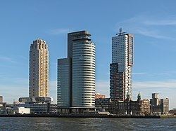 | ||
Rotterdam city skyline kop van zuid wilheminapier
Kop van Zuid is a neighborhood of Rotterdam, The Netherlands, located on the south bank of the Nieuwe Maas opposite the center of town. The district is relatively young and includes the Wilhelmina Pier as well as the V bounded by the Rose Street and railway line on one side and the Rotterdam-Dordrecht Hilledijk, Hill Street and Rijnhaven on the other.
Contents
- Rotterdam city skyline kop van zuid wilheminapier
- Map of Kop van Zuid Rotterdam Netherlands
- Skyline rotterdam nieuwe maas kop van zuid
- Buildings
- References
Map of Kop van Zuid, Rotterdam, Netherlands
The Kop van Zuid is built on old, abandoned port areas around the Binnenhaven, Entrepothaven, Spoorweghaven, Rijnhaven and the Wilhelmina Pier. These port sites and the Nieuwe Maas made for a large physical distance between the center and north of the Maas and southern Rotterdam. By converting this area into an urban area, and providing better infrastructure, planners sought to unite the northern and southern parts of the city.