
Prominence 252 m (827 ft) Elevation 267 m | OSI/OSNI grid Q910425 Listing Marilyn | |
 | ||
Mountain type mudstone, siltstone, sandstone Similar Brassel Mountain, Caher Mountain, Broaghnabinnia, The Bones, Caher West Top | ||
Knockanore Mountain (Irish: Cnoc an Fhómhair , meaning "hill of the autumn") is a large hill North Kerry, Ireland.
Contents
- Map of Knockanore Mtn Urlee Co Kerry Ireland
- GeographyEdit
- NameEdit
- Access to the summitEdit
- NatureEdit
- References
Map of Knockanore Mtn, Urlee, Co. Kerry, Ireland
GeographyEdit
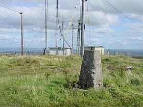
The 267-metre (876 ft) high hill stands around 5 km NE from Ballybunion. Its top hosts some broadcasting mats and a triangulation station. The hill is visible in the distance and the summit offers a good view on Shannon Estuary and a large part of Kerry's Atlantic coastline.
NameEdit
The English meaning of Cnoc an Fhómhair is hill of the autumn.
Access to the summitEdit
Knockanore summit can be accessed by a very short walk from the nearest road.
NatureEdit
The bogs surrounding the Knockanore are cited on The Irish naturalist, and are considered very interesting from the entomologist's point of view.
References
Knockanore Mountain Wikipedia(Text) CC BY-SA