
Time zone CET (UTC+1) Area code 51 | Local time Thursday 9:21 AM | |
 | ||
Municipality Skender Vakuf/Kneževo (seat) Website Official Kneževo Municipality Website Weather 6°C, Wind N at 5 km/h, 64% Humidity | ||
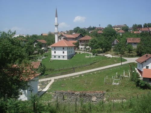
Kneževo also known as Skender Vakuf is small town in northwestern Bosnia and Herzegovina.
Contents
- Map of KneC5BEevo Bosnia and Herzegovina
- Name
- Geography
- Municipality
- History
- Culture
- Politics
- Demographics
- Notable people
- Annotations
- References
Map of Kne%C5%BEevo, Bosnia and Herzegovina
Name
Up until the 1992-1995 Bosnian War, the town was known as Skender Vakuf. After it was captured by Serb nationalist forces in 1992, however, the town was renamed Kneževo by the new authorities. Accordingly, many media outlets continue to refer to the area as Skender Vakuf-Kneževo.
Geography
Kneževo is located between the rivers Ugar, Vrbas and Vrbanja and surrounded by the mountain chains of Čemernica, Ranča in the west, Vlašić in the south and Ježica in the north-east. The municipality has an official altitude of 864 metres (2,835 ft), but really ranges from 600 to 1,493 metres (1,969 to 4,898 ft). Kneževo is 50 kilometres (31 mi) southeast of Banja Luka by the M56 motorway.
Neighbouring municipalities are Čelinac (extreme north), Kotor Varoš (east), Travnik, Dobretići, Jajce (south), Mrkonjić Grad and the city of Banja Luka (west). The southern border is defined by the border of the Republika Srpska with the Federation of Bosnia and Herzegovina, the country's other entity. The mountainous region in the south is forested and impracticable; its limestone mountains reach a height of 1,493 metres (4,898 ft).
Municipality
Today, the Kneževo municipality includes Bastaji, Bekići, Bokani, Borak, Bregovi, Vlatkovići, Golo Brdo, Gornji Korićani, Doline, Donji Korićani, Živinice, Imljani, Javorani, Kneževo, Kobilja, Korićani, Kostići, Milovići, Mokri Lug, Pavlovići, Paunovići, Petrovo Polje, Ravni Sto, Rađići, Ćeleši, Ćukovac, Čarići, Šolaji.
History
Roman basilica have been found in Imljani and Javorani, and remains of the Roman road from Servitium (Banja Luka) to Levsaba (Travnik) were also found in the vicinity. Tombstones of the Stećak type date back to the 14th and 15th centuries, when the area was part of the Kingdom of Bosnia. In 1463 the town became part of the Ottoman Empire and Islam was to become the dominant religion of the region. The charitable endowment (vakuf) that is reflected in the town's traditional name Skender Vakuf (after Ali-dedo Skender) contributed to urbanization. The Old Mosque was significant and one of the first in the region. It was destroyed, along with the New Mosque, in 1992 during the Bosnian War.
In the Korićani Cliffs massacre of 21 August 1992, some 200 Bosniaks and Croats detainees were massacred by the Bosnian Serbs Police and Army forces (in deep cliff in the canyon of Ilomska) river.
After the Bosnian War, part of the municipality was split off to form the Dobretići municipality of the Federation of Bosnia and Herzegovina entity.
Culture
The municipality houses several cultural monuments, such as the Old Church of St. Nicholas from 1757, the 18th-century Church of Prophet Elijah.
In Imljani there is a monument dedicated to 43 fallen soldiers of the Army of Republika Srpska who fell at the Vlašić battlefield on 20 March 1995.
Politics
The mayor of Skender Vakuf is Bore Škeljić, of the Serb Democratic Party (SDS).
Demographics
According to the preliminary results of the 2013 population census in Bosnia and Herzegovina, there were 3.958 inhabitants in Skender Vakuf town, and 10.428 inhabitants in the Skender Vakufmunicipality.
Municipality
After the war, the majority of the old Skender Vakuf municipality became part of the new Kneževo municipality of the Republika Srpska entity. Four Croatian pre-war settlements became part of the new Dobretići municipality of the Federation of Bosnia and Herzegovina entity.
Notable people
Annotations
According to the 1991 census, the municipality consisted of: Bastaji, Bokani, Borak, Bregovi, Brnjići, Bunar, Čarići, Ćukovac, Davidovići, Dobratići, Donji Orašac, Golo Brdo, Gornji Orašac, Imljani, Javorani, Kobilja, Kostići, Kričići - Jejići, Melina, Mijatovići, Milaševci, Mokri Lug, Paunovići, Pavlovići, Prisika, Rađići, Skender Vakuf, Slipčevići, Šolaji, Vitovlje Malo, Vlatkovići, Vukovići, Zapeće, Zasavica, Zubovići and Živinice.
In 1995, the municipality included Bastaji, Bokani, Borak, Bregovi, Čarići, Ćukovac, Golo Brdo, Imljani, Javorani, Kobilja, Kostići, Malići, Mokri Lug, Paunovići, Rađići, Kneževo, Šolaji, Vlatkovići and Živinice; the south-western settlements of Davidovići, Dobretići, Kričići and Melina became part of the municipality of Dobretići in the Federation of Bosnia and Herzegovina.