
Type Geological formation Underlies Glacial deposits Region Okanagan Highland | Unit of Okanagan highlands Thickness up to 3,200 ft (980 m) | |
 | ||
Sub-units Tom Thumb Tuff, Lower Member, Upper Member Overlies Sanpoil Volcanics & others | ||
The Klondike Mountain Formation is an early Eocene geological formation located in the northeast central area of Washington State. The formation, named for the type location designated in 1962, Klondike Mountain north of Republic, Washington, is composed of volcanic rocks in the upper unit and volcanics plus lacustrine (lakebed) sedimentation in which a lagerstätte with exceptionally well-preserved plant and insect fossils has been found, along with fossil epithermal hot springs.
Contents
The formation is the youngest in a group of formations which belong to the Challis Sequence rocks. The formation unconformably overlies rocks of the Eocene Sanpoil Volcanics and much older Triassic and Permian formations. The formation is bounded on its edges by a series of high-angle strike slip faults, which have contained the Klondike Mountain Formation in a series of graben structures, such as the Republic Graben.
Location
The formation is located in northern Ferry County, Washington, with the majority of the sedimentation in the Republic and Curlew Basins on the east and in the Toroda Creek area to the north west. The town of Republic, Washington is situated at the southern end of the formation, with outcrops within the city itself. The Curlew basin is situated north of Republic, with the northern edge along the Kettle River and the community of Curlew, Washington near the northeastern edge.
The formation is the southernmost of a string of preserved Eocene highland lakebeds in Washington state and British Columbia. The lake system, within the Okanagan highlands, extends from the Klondike Mountain Formation north approximately 1,000 kilometres (1,000,000 m) in to southern central British Columbia.
Age
Early dating of the formation was based primarily on identification and correlation of the fossils found in the Tom Thumb Tuff, with Joseph Umpleby in 1910 reporting a putative age of early Miocene. This date was based in examination of fossils by C. R. Eastman, who thought them to be similar to those found in the Florissant Formation of Colorado, which at the time was also considered Miocene. This age was retained in the 1928 work of Edward W. Berry, who included the Klondike Mountain Formation fossil lakebeds as part of the Latah Formation. The age of the Formation has been revised in the following hundred years, with Roland W. Brown identifying the deposits as being older than the Latah Formation in 1936. In a later written communication circa 1958, Brown again revised the age still older, stating the fossils found in the area of Mount Elizabeth indicated an Oligocene age. This age was used by R.L. Parker and J. A. Calkins in their 1964 work on the Curlew Quadrangle of Ferry County. Since then the fossil-bearing strata of the Formation have been radiometrically dated, to give a current estimate of the Ypresian, the mid stage of the early Eocene,49.4 ± .5 million years ago.
Lithology
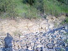
Parker and Calkins in 1964 noted the association of the Klondike Mountain Formation with the gold and silver deposits of the Republic District and suggested it as a potential host to more ore deposits in the Curlew Quadrangle. The epithermal gold deposits occurring in the Sanpoil volcanics terminate directly below the unconformity where the volcanics contact the base of the Klondike Mountain Formation or sometimes penetrate into the Formation's lowest unit. Hydrothermal sinter deposits are known from the lowest portions of the Formation and are thought to represent hydrothermal eruption areas. In general the lower portions of the Formation have a large amount of hydrothermal alteration, and areas around vents are rich in pyrite and silica. two products of natural hydrothermic sintering. The areas above that show a transition to mudstones, siltstones and sandstones grading from fine-grained material into coarser materials moving up the strata column. The finely-bedded stones show the greatest numbers of fossils and the finest preservation of details.
Paleobiota
The lake bed sediments preserve a diverse array of plants, insects, and fishes, notably the biota called the Republic flora. The Okanagan lake system, which includes the Klondike Mountain Formation, has been classified as one of the great Canadian lagerstätten. The paleoenvironment preserved in the lake deposits is that of a mesic forest, similar in rainfall to that found today along the modern Washington State and British Columbia coast. The climate of the region offered a moderate amount of summer heat, with chilly winters not cold enough to sustain snow cover (a lower mesothermal to upper microthermal climate).
Over a dozen different Rosaceae genera, both extant and extinct, have been identified in the formation. These fossils are some of the oldest reliable macrofossils (excluding ancient fossil pollen) for the family. The neuropteran insects (lacewings and their allies) identified as of 2014 include species from the families Berothidae, Chrysopidae, Hemerobiidae, Ithonidae (including Polystoechotidae), Nymphidae, Osmylidae, and Psychopsidae. A number of mecopteran species belonging to the families Cimbrophlebiidae, Dinopanorpidae, Eorpidae, and Panorpidae are also known.