
Country United States County Ferry FIPS code 53-57850 Elevation 783 m Zip code 99166 Local time Monday 10:01 PM | Time zone Pacific (PST) (UTC-8) GNIS feature ID 1525005 Area 4.12 km² Population 1,083 (2013) Area code 509 | |
 | ||
Weather 4°C, Wind S at 5 km/h, 78% Humidity | ||
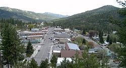
Republic washington aerials
Republic is a city in Ferry County, Washington, United States. The population was 1,073 at the 2010 census, a 12.5% increase over the 2000 Census. It is the county seat of Ferry County.
Contents
- Republic washington aerials
- Map of Republic WA 99166 USA
- History
- Geography
- 2010 census
- 2000 census
- References
Map of Republic, WA 99166, USA
History
Republic was founded by gold prospectors in the late 19th century. The Mining District of Eureka was established after gold was found on Eureka Creek. Philip Creasor platted a townsite to be named Eureka. Another strike was made nearby on Granite Creek. The Great Republic claim, found by Thomas Ryan and Philip Creasor on March 5, 1896, was the highest producer of gold. By 1900 the settlement was booming. A post office was established but postal authorities rejected the name Eureka because there was already a town by that name in Clark County, Washington. The citizens then decided to honor the Great Republic mining claim by proposing the name Republic. This name was accepted and the settlement was incorporated as a city on May 22, 1900.
Republic's prominence, initially brought on by the gold rush, started to fade as prospectors and those who supported the mining industry moved away. During the years between 1900 and 1910, the town lost over half its population. Despite this, mining has continued to be an important part of life in Republic, as gold is still mined for in the mountains surrounding the town. Mining is celebrated in the local Prospector's Days, held during the second weekend in June, where locals honor their prospector roots by competing in mining and logging competitions, panning for gold, and watching an old west gun fight. Today, the town of 1,100 is mainly sustained by those people in surrounding farms and ranches, miners who work at the local mine, and tourists looking for a quieter, slower pace of life.
Republic is also the site of the Stonerose Interpretive Center and Fossil Site, famous for the Eocene fossils found in a 49 mya lake bed at the north end of Republic. At the Ferry County Fairgrounds, located three miles (5 km) east of town on State Route 20, is the Ferry County Carousel originally built between 1895 and 1900. Republic has many businesses that line Clark Ave (the main street through town) including Anderson's Grocery, which is over a hundred years old. The Kinross Gold company and Ferry County Memorial Hospital are two of largest employers in the County.
Geography
Republic is located at 48°38′53″N 118°44′6″W (48.648159, −118.734947).
According to the United States Census Bureau, the city has a total area of 1.59 square miles (4.12 km2), all of it land.
Republic is located near the source of the Sanpoil River in a long valley bordered by the Okanagan Highlands to the west and the Kettle mountain range to the east. Curlew Lake, 7 miles (11 km) long (Elev: 2400 ft), provides fishing and boating to summer visitors northeast of Republic. Swan Lake is small mountain lake 14 miles (23 km) to the south of Republic and also serves to be a popular lake for local residents and tourists to visit. Republic is surrounded by the Colville National Forest and to the south is the Colville Indian Reservation.
Republic experiences a humid continental climate (Köppen Dfb) with cold winters, warm summers and fairly even precipitation year-round, with a drying trend in summer, though there is a secondary uptick in rainfall from April thru June, unlike in much of the rest of the state.
2010 census
As of the census of 2010, there were 1,073 people, 493 households, and 263 families residing in the city. The population density was 674.8 inhabitants per square mile (260.5/km2). There were 536 housing units at an average density of 337.1 per square mile (130.2/km2). The racial makeup of the city was 89.6% White, 0.1% African American, 2.7% Native American, 1.9% Asian, 0.1% Pacific Islander, 1.4% from other races, and 4.3% from two or more races. Hispanic or Latino of any race were 2.7% of the population.
There were 493 households of which 23.7% had children under the age of 18 living with them, 33.7% were married couples living together, 13.6% had a female householder with no husband present, 6.1% had a male householder with no wife present, and 46.7% were non-families. 37.7% of all households were made up of individuals and 14.6% had someone living alone who was 65 years of age or older. The average household size was 2.05 and the average family size was 2.68.
The median age in the city was 45.3 years. 19.7% of residents were under the age of 18; 7.6% were between the ages of 18 and 24; 22.1% were from 25 to 44; 29.9% were from 45 to 64; and 20.7% were 65 years of age or older. The gender makeup of the city was 46.1% male and 53.9% female.
2000 census
As of the census of 2000, there were 954 people, 411 households, and 244 families residing in the city. The population density was 602.9 people per square mile (233.1/km²). There were 500 housing units at an average density of 316.0 per square mile (122.2/km²). The racial makeup of the city was 92.56% White, 0.84% African American, 2.73% Native American, 0.21% Asian, 0.10% Pacific Islander, 0.73% from other races, and 2.83% from two or more races. Hispanic or Latino of any race were 1.99% of the population.
There were 411 households out of which 31.4% had children under the age of 18 living with them, 44.0% were married couples living together, 11.7% had a female householder with no husband present, and 40.4% were non-families. 36.5% of all households were made up of individuals and 15.6% had someone living alone who was 65 years of age or older. The average household size was 2.25 and the average family size was 2.96.
In the city, the population age distribution is spread out with 26.0% under the age of 18, 7.3% from 18 to 24, 24.4% from 25 to 44, 27.9% from 45 to 64, and 14.4% who were 65 years of age or older. The median age was 40 years. For every 100 females there were 93.9 males. For every 100 females age 18 and over, there were 88.8 males.
The median income for a household in the city was $25,284, and the median income for a family was $30,357. Males had a median income of $28,750 versus $24,286 for females. The per capita income for the city was $14,427. About 20.2% of families and 24.0% of the population were below the poverty line, including 31.5% of those under age 18 and 17.6% of those age 65 or over.