
Parent range Rhön Range Rhön Mountains | Elevation 808 m | |
 | ||
Similar Großer Auersberg, Auersberg, Eierhauckberg, Dammersfeldkuppe, Reesberg | ||
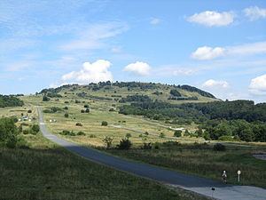
The Kleiner Auersberg is a mountain, 808 m above sea level (NN), in the Bavarian part of the Rhön mountains. It is situated five kilometres southwest of the centre of Wildflecken in the county of Bad Kissingen on the watershed between the Sinn and Kleiner Sinn.
Map of Kleiner Auersberg, 97772 Wildflecken, Germany
The Kleiner Auersberg is only partly wooded and its summit is thus a good viewing point. In good visibility the views extend as far as the Kreuzberg in the east, Dreistelzberg and Spessart in the southwest as far as the Vogelsberg in the northwest. In very good visibility the Taunus and the skyscrapers of Frankfurt am Main are visible.
The Kleiner Auersberg lies within the Wildflecken Training Area, established in 1938. The entire terrain is a military out-of-bounds area. The only opportunity for civilians to climb the Kleiner Auersberg is on the two Volkswandertage ("people's walking days"), which take place annually on a summer weekend. Due to the good views, usually one of the prescribed routes leads to the summit. A good two kilometres east-northeast rises the slightly higher and densely wooded Großer Auersberg. Neither should be confused with the Auersberg near Hilders in the Hessian part of the Rhön.