
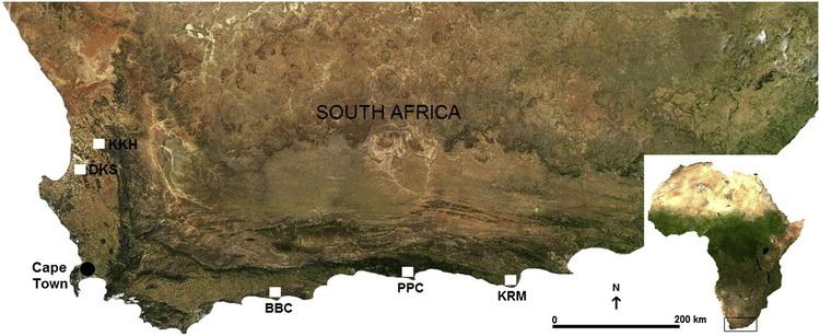
Location Tsitsikamma coast, Humansdorp district of Eastern Cape Province, South Africa | ||
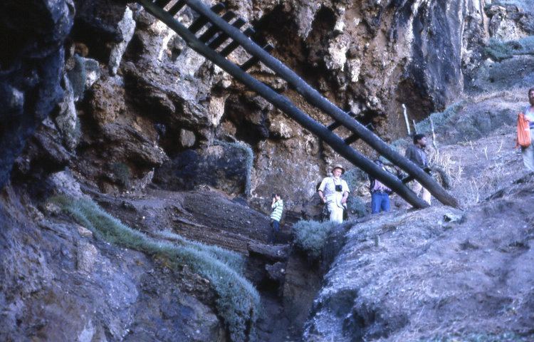
The Klasies River Caves are a series of caves located to the east of the Klasies River mouth on the Tsitsikamma coast in the Humansdorp district of Eastern Cape Province, South Africa. The three main caves and two shelters at the base of a high cliff have revealed evidence of middle stone age-associated human habitation from approximately 125,000 years ago. The 20 metres (66 ft) thick deposits were accumulated from 125,000 years ago. Around 75,000 years ago, during cave remodelling, the stratigraphic sediments were moved out into external middens.
Contents
In 2015, the South African government submitted a proposal to add the caves to the list of World Heritage Sites.
From 1960, Ronald Singer, Ray Inskeep, John Wymer, Hilary Deacon, Richard Klein and others suggested the excavation yielded the earliest known remains of anatomically modern humans and behaviourally modern humans in the world. Further analysis suggested that those specimens fall "outside the range of modern variation".
Middle Stone Age behaviour
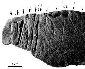
There is a 20 metres (66 ft) thick accumulation of deposits, both inside the caves and outside against the cliff face, proving that Klasies River Mouth people knew how to hunt small game, fish (later), gather plants and roots, cook by roasting on hearths, and manage their land (later). There is extensive evidence of shellfish collecting; MSA stone artefact technology; gathering plants, roots and flowers for food; cooking plants, corms, seal, penguins, and antelope meat on hearths with fire; general organisation of the settlement; and land/veld management by fire. The evidence also appears to indicate that their presence was seasonal or migratory. There is also evidence of cannibalism, charred and carved 'modern human' bones discarded with other food remnants.
While Middle Stone Age (MSA) assemblage associated with those people are described as anatomically modern, there is ongoing debate about when they were also behaviourally modern. There is a marked difference between the Paleolithic stone technology used in the earliest layers from 125,000 years ago, and the superior MST blades of the 70,000-year-old Howiesons Poort period that used raw material which had been 'mined' 20 kilometres inland. There is also a differentiation between the Paleolithic food detritus that accumulated underfoot inside the caves 125,000 years ago, but was ejected and accumulated into external middens by the MST occupants circa 75,000 years ago. This 'housekeeping' is an indicator that 'at least half of our species' had evolved 'modern behaviour' by the MSA.
Analysis of 14 proximal ulnar dimensions compared to morphological properties of African archaic humans, and Levantine Mousterian, archaic European humans, west Asian and, European Upper Paleolithic, African Epipaleolithic and recent modern human also of recent African descent suggest an archaic total morphological pattern for the KRM specimens. "MSA-associated humans from KRM may not be as modern as has been claimed from the craniofacial material"
The hominin specimens include cranial fragments, mandibles with teeth, and a few postcranial remains: ulna and five metatarsal bones.
Discovery and excavation
The artifacts and bones were originally reported by Paul Haslem and Ludwig Abel, then in 1960 Ray Inskeep and Ronald Singer identified the artifacts as Middle Stone Age. In 1967 and 1968 Ronald Singer and John Wymer started extensive excavations, with their initial findings published in 1972 by the University of Chicago Press. Since 1984 research has been continued by Hilary Deacon.
The site is now protected by the South African Heritage Resources Agency (SAHRA), and the Department of Environment Affairs and Tourism.
Locations
The five caves are dotted eastwards along the coast within 2 kilometres of Klasies River mouth, and the complete stretch to Druipkelder Point is designated as a National heritage site.
(Locations – best viewed in Google Earth)