
Local time Thursday 3:33 AM | Population 3,500 (2005) | |
 | ||
Weather 1°C, Wind SE at 2 km/h, 96% Humidity | ||
Klarenbeek is a village in the eastern Netherlands with approximately 3500 inhabitants. The village belongs to two municipalities, Apeldoorn and Voorst, with the municipality border situated in the middle of the village.
Contents
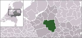
Map of Klarenbeek, Netherlands
Klarenbeek is named after an estate situated next to the Klaarbeek. This estate was later also named Klarenbeek. Both Klaarbeek and Klarenbeek translate to "Clear Stream" in English.
Klarenbeek has its own railway station, Klarenbeek railway station, 2 km northeast of the village on the railway line between Apeldoorn and Zutphen. The station can be reached by Buurtbus service. This service connects with the station hourly, from 7am to 6pm. The railway station lies within the borders of the municipality of Voorst.
The village is located along the European hiking route E11, locally known as the Marskramerpad or Handelsweg.
History
The village of Klarenbeek was founded in 1732 when a copper mill was established next to the Beekbergse Beek. In 1764, this copper mill was bought by the family of Krepel. To increase the capacity of the mill, the Beekbergse Beek was enlarged and heightened, causing the water to fall down faster. Later, a water reservoir called "De Wiert" was added to this. The Wiert still exists, and when the winters are cold enough, it is a common location for ice skating. The Krepel family built homes for their employees, creating the first non-farm houses in Klarenbeek.