
Topo map USGS Kitt Peak Elevation 2,097 m Parent range Quinlan Mountains | Easiest route Road Prominence 638 m | |
 | ||
Similar Mount Hopkins, Mount Turnbull, Roof Butte, Mount Graham, Chiricahua Peak | ||
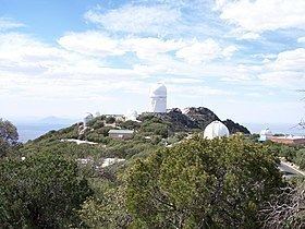
Kitt Peak (O'odham: Ioligam) is a mountain in the U.S. state of Arizona, and at 6,883 feet (2,098 m) is the highest point in the Quinlan Mountains. It is the location of the Kitt Peak National Observatory. The radio telescope at the Observatory is one of ten dishes comprising the Very Long Baseline Array radio telescope.
Map of Kitt Peak, Arizona 85634, USA
The peak was named in English by County Surveyor George J. Roskruge for his sister, Phillippa, who was the wife of William F. Kitt. On his 1893 Pima County Survey map, Roskruge spelled the name 'Kits'. At the request of the wife of George F. Kitt, the spelling was changed by decision in 1930.
Kitt Peak is the second-highest peak on the Tohono O'odham Indian reservation, and as such is the second-most sacred after Baboquivari Peak. Near the summit is I'itoi's Garden, the summer residence of the nation's elder brother deity. The name Ioligam means "red stick" in reference to the abundance of manzanita bushes on and around the mountain.