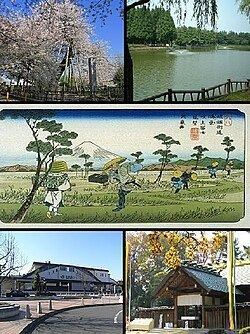
– Tree Sakura Phone number 048-591-1111 Population 67,319 (Feb 2016) | Region Kantō Area 19.82 km² Local time Thursday 6:57 AM | |
 | ||
Weather 2°C, Wind W at 14 km/h, 78% Humidity Points of interest Glico Pia East, Kitamoto Total Park, Nakamaru Ryokuchi Park, Azumaasama Shrine, Tenjinshita Park | ||
Kitamoto (北本市, Kitamoto-shi) is a city located in Saitama Prefecture, in the central Kantō region of Japan. As of 1 February 2016, the city had an estimated population of 67,319 and a population density of 3400 persons per km². Its total area was 19.82 square kilometres (7.65 sq mi).
Contents
- Map of Kitamoto Saitama Prefecture Japan
- Geography
- Surrounding municipalities
- History
- Economy
- Education
- Railway
- Highway
- Noted people from Kitamoto
- References
Map of Kitamoto, Saitama Prefecture, Japan
Geography
Located in east-central Saitama Prefecture, Kitamoto is on the central reaches of the Arakawa River, and is within commuting distance of downtown Tokyo.
Surrounding municipalities
History
Kōnosu-shuku was one of the post stations on the Nakasendō highway until 1602, when it was relocated north; the original location was renamed Motojuku, and later, Kitamotojuku, which is the origin of the name of the modern city. With the establishment of the municipalities system on April 1, 1889, Kitamotojuku was merged with several neighboring hamlets to form the village of Ishito within Kitaadachi District, Saitama. On February 11, 1943, Ishito was merged with neighboring Nakamuru to form Kitamotojuku Village. On November 3, 1959, the village was elevated to town status, becoming Kitamoto Town. Kitamoto attained city status on November 3, 1971.
Economy
Due to this location, Kitamoto is primarily a bedroom community with a high percentage of its population commuting to either Saitama City or the Tokyo metropolis for work.
Education
Kitamoto has eight elementary schools, two middle schools and one high school.
