
Population 5,371 Sovereign state United Kingdom Local time Wednesday 6:08 PM | OS grid reference TF304385 Post town BOSTON Dialling code 01205 | |
 | ||
Weather 14°C, Wind SW at 10 km/h, 64% Humidity | ||
Kirton, or Kirton in Holland is a village and civil parish within the Borough of Boston, in Lincolnshire, England. The population of the civil parish at the 2011 census was 5,371.
Contents
- Map of Kirton UK
- History
- Church
- Grammar school
- The Old Kings Head
- Geography
- Research centre
- Notable people
- References
Map of Kirton, UK
History
Kirton was the seat of Lincolnshire's first Saxon kings, later becoming a market town.
In the Domesday account the village is written as “Cherchetune”. It consisted of 52 households, with 30 freemen and 16 smallholders, 12 ploughlands, 10 plough teams, a meadow of 60 acres (0.24 km2), a church and 2 salthouses. In 1066 lordship of the manor was held by Earl Ralph, being transferred to Count Alan of Brittany in 1086.
Hitherto, the parish had formed part of Boston Rural District, in the Parts of Holland. Holland was one of the three divisions (formally known as parts) of the historic county boundaries of Lincolnshire. Since the Local Government Act of 1888, Holland had been in most respects, a county in itself.
In 1885 Kelly's Directory recorded Kirton as having a station on the Great Northern Railway. This closed in 1961.
There existed Congregational and Wesleyan chapels and almshouses for four poor women. The village market was then disused. The Gas Consumers' Company Ltd was formed here in 1865. Principal landowners were The Mercers' Company, Sir Thomas Whichcote DL, E. R. C. Cust DL, the Very Rev. Arthur Percival Purey-Cust DD, and Samuel Smeeton, whose residence was the "modern white building" of D'Eyncourt Hall. Agricultural production within the 8,962 acres (36.27 km2) parish consisted of wheat, beans and potatoes, and there was a "large quantity of pasture land" and 676 acres (2.74 km2) of marsh land. The 1881 the ecclesiastical parish population was 2,011, the civil parish, 2,580.
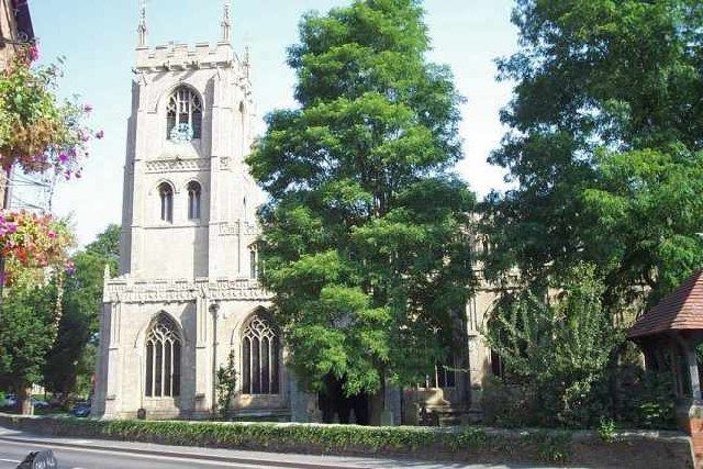
Church
The parish church is dedicated to St Peter and St Paul. The transepts had double aisles like those of Algarkirk and Spalding but in 1804 the central tower and transepts were pulled down and the chancel shortened, the architect (Hayward) using gunpowder to remove the tower. Rebuilding was completed by 1809. In 1900 a restoration of the church was undertaken by architect Hodgson Fowler.
Grammar school
In 1624 Thomas (later Sir Thomas) Middlecott was empowered by a Private Act of Parliament to found a Free Grammar School for the instruction of the Latin and Greek languages, and English commercial and agricultural education, to children from the parishes of Kirton, Sutterton, Algarkirk and Fosdyke. By 1835 the school had 40 pupils, partly free and partly fee-paying. The (head) Master appointed in 1773, Rev. Charles Wildbore (c. 1736–1802), and later his son by the same name (1767–1842), were alleged to have been diverting surplus income from the school's endowments for their own use, and failing to maintain educational standards. This culminated in a parliamentary report, and the management of the school was ultimately restructured in 1851. By 1885, William Cochran was Master, and a new school house had been erected adjacent to his residence. Under a scheme of the Endowed School Act, amended in 1898, the school was ranked as a "second-grade" Grammar School.
In the 1830s a girls' school for 14 day and boarding pupils, and a Sunday School for 32 males and 16 females existed in the village.
The village now has a secondary modern school: Thomas Middlecott Academy.
The Old King's Head
The Old King's Head, Kirton is a former public house listed as a Grade II historic building. The earlier part of it was built at the end of the 16th century and it underwent major alterations in 1661 in Artisan Mannerist Style. It is red brick in English bond, with recent tiles on a former thatched roof. It became a domestic residence in the 1960s, but had fallen into disrepair and was purchased in 2016 by Heritage Lincolnshire, which has assigned over £2 million for its restoration.
Geography
Kirton is on the A16, B1397 and B1192 south of Boston, near Frampton and Sutterton. Several satellite villages and hamlets take their name from Kirton, including Kirton Holme, Kirton End, Kirton Fen, Kirton Skeldyke, and Kirton Marsh. Until 1970, the village had the Kirton railway station.
Local governance of the village was reorganised on 1 April 1974, as a result of the Local Government Act 1972. Kirton parish forms its own electoral ward.
Kirton falls within the drainage area of the Black Sluice Internal Drainage Board.
Research centre
The Kirton Research Centre, which was closed in 2009, was nearby. Ownership of the 120-acre (0.49 km2) centre was transferred from DEFRA to the University of Warwick in April 2004 and became part of Horticulture Research International. In August 2009 the University closed the centre as public and private funding failed to cover running costs.