
Population 518 (2011) Sovereign state United Kingdom Dialling code 01335 | OS grid reference SK267509 Post town ASHBOURNE | |
 | ||
Kirk ireton starling roost
Kirk Ireton is a village and civil parish in Derbyshire, England. The population of the civil parish (including Callow) at the 2011 Census was 518. It is located 4 miles south west of Wirksworth nestling on a hillside, near to Carsington Water 700 ft above sea level. Ireton is a corruption of Hyre-Tun in the Saxon and means 'The Irishman's Enclosure'. 'Kirk' was added after the Norman invasion and the building of the church. The village dates back at least as far as the Bronze Age.
Contents
Map of Kirk Ireton, Ashbourne, UK
The village
Kirk Ireton remains what it has always been, an agricultural village. Following the Second World War the number of working farms dropped from over thirty to half a dozen in the space of 40 years. The last cow was turned down Main Street in the late 1980s, but Fords, Matkins, Rowlands, Walkers and Wards still farm locally as they have done for many generations. Many of the former farm buildings have been adapted into houses. Much of the older part of the village dates back to the 17th century and is mostly built from sandstone, quarried locally.
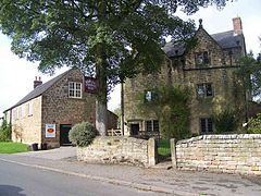
One of the oldest buildings in the village is the Barley Mow pub, which was one of the last premises in the country to accept decimalization, as the 87-year-old landlady, Mrs Lillian Ford did not hold with the new money. The parish previously housed at least four other public houses; The Wheatsheaf, Old Bull's Head, The Windmill and The Gate.
Kirk Ireton's Holy Trinity Church (originally St Lawrence's) dates back to Norman times with the earliest parts being the 3 bayed south and north arcades. The tower and the chancel are Perpendicular. It has an interesting custom known as 'roping for weddings', when the village children put a rope across the road and the bride and groom are not allowed to leave the church until a toll has been paid in silver by the groom.
The village still celebrates a Wakes week, which starts on Trinity Sunday, the church's patronal festival. A procession of villagers is led by a local brass band, from the Barley Mow pub to the church for thanksgiving. Various events take place during the week, with a more major all day event on the Saturday.
The Post Office (as pictured) was closed at the beginning of 2008. It is now (2010) open as a community shop. The premises were originally stables and the restored hay racks are, to the delight of visitors, still in place above shelving along one wall.