
Admin. region Oberbayern Elevation 417 m (1,368 ft) Area 25.23 km² Population 3,151 (31 Dec 2008) | Time zone CET/CEST (UTC+1/+2) Local time Tuesday 5:34 PM Postal code 83417 | |
 | ||
Weather 11°C, Wind W at 5 km/h, 54% Humidity | ||
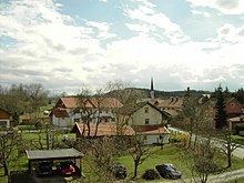
Kirchanschöring is a municipality in the district of Traunstein in Bavaria, Germany. The community is located in the Rupertiwinkel and it borders on the eastern waterside of the Waginger See, although the town itself is some kilometers away from the lake.
Contents
Map of 83417 Kirchansch%C3%B6ring, Germany
History
Kirchanschöring earlier belonged to the prince-bishopric Salzburg. In 788, Kirchanschöring was first mentioned in a document as a possession of the archbishop Arno. In that time, it was called Anschering. This name probably goes back to the name Ansheri or Anskar, relating to a person who settled there. In the course of the centuries, the name changed into Anschering and later, after the construction of the church in the 14th century, Kirchanschöring.
Economy
The internationally known companies Meindl as well as Royalbeach have their headquarters in Kirchanschöring. Further main pillars are tourism, trade and agriculture.