
Country United States Incorporated 1857 Elevation 166 m Population 13,074 (2013) | Settled 1771 Time zone Eastern (EST) (UTC-5) Area 5.7 km² Local time Tuesday 8:53 AM | |
 | ||
Weather -4°C, Wind NE at 14 km/h, 94% Humidity | ||
Kingston is a borough in Luzerne County, Pennsylvania, United States, on the Susquehanna River opposite Wilkes Barre. As of the 2010 census, the population was 13,182.
Contents
- Map of Kingston PA 18704 USA
- History
- Geography
- Demographics
- National Register of Historic Places
- In film and television
- Government
- Legislators
- Notable people
- References
Map of Kingston, PA 18704, USA
History
Kingston was named after Kingston, Rhode Island, and incorporated as a borough in 1857. Kingston has adopted a home rule charter which became effective in January 1976.
Kingston has a rich history as a pivotal pioneer in American education. In 1775, a new school was erected on the site of one established in 1773, which is said to have been the first public school in Pennsylvania. The borough is also home to the Upper School campus of Wyoming Seminary, a prestigious college preparatory school founded in Kingston in 1844. The school was founded with a total of just 31 students—17 boys and 14 girls—enrolling in the first year. Today, Wyoming Seminary's historic campus hosts roughly 450 students and its Lower School grounds in Forty Fort host students from pre-K through eighth grade.
In June 1972, Kingston was devastated by the flooding of Hurricane Agnes. The hurricane, at the time the most significant natural disaster in American history, wreaked havoc on Kingston and neighboring Wilkes-Barre, causing a state of emergency. The natural disaster earned national attention and a visit from President Richard Nixon who recruited Wyoming Seminary graduate Frank Carlucci, Nixon's head of the Department of Health, Education, and Welfare, as a point man to oversee flood recovery efforts.
Geography
Kingston is located at 41°16′N 75°53′W (41.2665, -75.8895).
According to the United States Census Bureau, the borough has a total area of 2.2 square miles (5.7 km2), of which 2.1 square miles (5.5 km2) is land and 0.08 square miles (0.2 km2), or 3.61%, is water. It is separated from Wilkes-Barre by the Susquehanna River and the boundary of the latter's Kirby Park. Its numbered routes are U.S. Route 11 and Pennsylvania Route 309, which follows the Cross Valley Expressway from the Back Mountain area to Interstate 81 and Route 115 east of the city. Market Street and Pierce Street connect Kingston with center city via bridges.
Demographics
As of the census of 2000, there were 13,855 people, 6,065 households, and 3,372 families residing in the borough. The population density was 6,461.6 people per square mile (2,499.7/km2). There were 6,555 housing units at an average density of 3,057.1 per square mile (1,182.7/km2). The racial makeup of the borough was 96.84% White, 0.77% African American, 0.07% Native American, 1.53% Asian, 0.01% Pacific Islander, 0.29% from other races, and 0.50% from two or more races. Hispanic or Latino of any race were 0.80% of the population.
There were 6,065 households, out of which 23.1% had children under the age of 18 living with them, 40.7% were married couples living together, 11.3% had a female householder with no husband present, and 44.4% were non-families. 40.1% of all households were made up of individuals, and 20.5% had someone living alone who was 65 years of age or older. The average household size was 2.16 and the average family size was 2.94.
In the borough the population was spread out, with 19.7% under the age of 18, 7.5% from 18 to 24, 25.6% from 25 to 44, 22.8% from 45 to 64, and 24.4% who were 65 years of age or older. The median age was 43 years. For every 100 females there were 83.9 males. For every 100 females age 18 and over, there were 78.9 males.
The median income for a household in the borough was $33,611, and the median income for a family was $45,578. Males had a median income of $34,069 versus $24,482 for females. The per capita income for the borough was $20,568. About 8.2% of families and 11.3% of the population were below the poverty line, including 11.7% of those under age 18 and 10.3% of those age 65 or over.
National Register of Historic Places
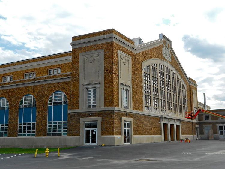
In addition to Fleck Hall on the campus of Wyoming Seminary, the Kingston Armory and Market Street Bridge are listed on the National Register of Historic Places. The borough is also home to the historic Hoyt Library, the former Samuel Hoyt residence, which was bequeathed to Kingston Borough for a public library by his son, Frank Weston Hoyt. With the financial support of Kingston Borough Council, the Library opened on January 1, 1928.
In film and television
The 2013 film The English Teacher is set in Kingston, though it was not filmed there. The film features several references to the Wyoming Valley region, including a mention of Wilkes University.
Government
Kingston operates under a home rule charter. The legislative function is vested in a seven-member council. Kingston's charter also calls for a full-time municipal administrator. .
In June 2012, the borough was 54 percent Democratic, a reversal from the early 1990s when it was a 60 percent Republican borough.