
Topo map USGS Franklin Lake NW Prominence 400 m | Elevation 3,362 m | |
 | ||
Easiest route From the Ruby Crest Trail: steep hike Similar Snow Lake Peak, Liberty Peak, Mount Fitzgerald, Thomas Peak, Humboldt Peak | ||
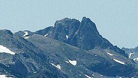
King Peak is the southernmost summit above 11,000 feet (3,400 m) in the Ruby Mountains of Elko County, in northeastern Nevada in the western United States. To the west is Rattlesnake Canyon, and to the east is Overland Creek Canyon, which drains into the Ruby Valley). The Ruby Crest National Recreation Trail passes just to the east on its way north from Overland Lake. The summit is located at about 29 miles (47 km) southeast of the community of Elko, in the Humboldt National Forest and the Ruby Mountains Wilderness.
Map of King Peak, Nevada 89815, USA
The peak is named for Clarence King, who explored this region in 1869 during the Geological Exploration of the Fortieth Parallel and later became first chief of the United States Geological Survey.
References
King Peak (Nevada) Wikipedia(Text) CC BY-SA