
 | ||
Similar Loch Humphrey, Duncolm, Campsie Fells, Erskine Bridge, Mar Hall | ||
The Kilpatrick Hills are a range of hills in central Scotland, stretching from Dumbarton in the west to Strathblane in the east. Strathblane divides the Kilpatricks from the Campsie Fells to the east, while to the north is part of the Loch Lomond and the Trossachs National Park. To west and south the hills are fringed by the settlements of Balloch, Dumbarton, Milton, Bowling, Old Kilpatrick, Clydebank, Bearsden and Milngavie. The majority of the range is within West Dunbartonshire, although it extends into the East Dunbartonshire and Stirling areas.
Contents
Map of Kilpatrick Hills, Clydebank, UK
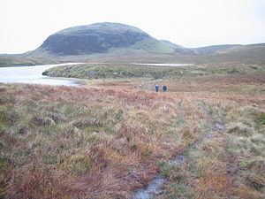
The highest points in the range are Duncolm (1,314 feet (401 m)) and Fynloch (1,313 feet (400 m)). The Kilpatricks offer a number of viewpoints and places of interest: among the best known are Doughnot Hill and The Whangie. The area features several reservoirs.
The hills are of volcanic origin, modified by subsequent glaciation.
Geology
The Kilpatrick Hills are a part of the Clyde Plateau Lavas. These are about 340 million years old. Basaltic types of rocks (lavas, tuffs and agglomerates) predominate here. These are produced by denudation of the successive flows.
The Whangie in the north of the Kilpatricks is of particular interest to geologists and casual walkers alike. It consists of a slice of the hillside that has been separated from the main slope. This has created a narrow chasm up to 10 metres (33 ft) high and about 100 metres (330 ft) in length through which visitors can walk. It has commonly been explained as result of glacial plucking, but more recent research indicates that a translational landslide was the cause. During an ice age, a glacier slowly undermined the crag, opening up cracks in the rock and causing this chasm to form.
The etymology of the Whangie's name is obscure but it might derive from the old Scots for slice (as in whang o' cheese). Local folklore suggests that it was created by the devil flicking his tail as he flew past.
Archaeological sites
There are several archaeological sites on the south-facing slopes of the hills. The chambered cairn at Carnhowit is situated on the plateau top near the edge of Cochno Loch, at a height of 275 metres (902 ft). There are three other cairns, which may be from the bronze age period. One known as Maidens Paps is nearby, just to the east of Jaw Reservoir which abuts Cochno Loch. Both it and another cairn on Cochno Hill are at a height of about 250 metres (820 ft), and the third cairn is sited at Wester Duntiglennan at approximately 150 metres (490 ft) height. Cists have been found at Cochno and Duntocher, and on the slopes below 150 metres (490 ft) several groups of cup and ring marks have been found on outcrops, mostly around Auchnacraig and Whitehill, with other groups further west along the slopes to above Bowling, West Dunbartonshire.
Topology and toponymy
The hills are named after the village of Old Kilpatrick, which lies at their southern foot. The following table lists summits over 1,000 feet (300 m). Duncolm, the highest point of the range, is also the only Marilyn in the Kilpatricks, having a relative height of over 150 metres (490 ft).