
Postcode 25xxx Area 13,250 km² Area code 027 | Zone Northern Time zone EAT (UTC+3) Website kilimanjaro.go.tz Population 1.64 million (2012) | |
 | ||
Colleges and Universities Kilimanjaro Christian Medical, Moshi Co‑operative University, Stefano Moshi Memorial Points of interest Mount Kilimanjaro, Uhuru Peak, Furtwängler Glacier, Arrow Glacier, Rebmann Glacier | ||
Kilimanjaro Region is one of Tanzania's 30 administrative regions. The regional capital is the municipality of Moshi. According to the 2012 national census, the region had a population of 1,640,087, which was lower than the pre-census projection of 1,702,207. For 2002-2012, the region's 1.8 percent average annual population growth rate was the 24th highest in the country. It was also the eighth most densely populated region with 124 people per square kilometer.
Contents
Map of Kilimanjaro Region, Tanzania
The region is home to a portion of Kilimanjaro National Park. The region is bordered to the north and east by Kenya, to the south by the Tanga Region, to the southwest by the Manyara Region, and to the west by the Arusha Region.
Districts
The region is administratively divided into seven districts:
History
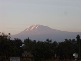
The Kilimanjaro Region borrowed its name from the tallest mountain in Africa, Mount Kilimanjaro.
Of the region's seven districts, five traditionally had Chagga settlements, which are Hai District Council, Moshi Municipal Council, Moshi District Council, Rombo District Council, and Siha District Council. The other two, Mwanga District Council and Same District Council, have historically included Pare settlements. However, during colonial rule in the late 19th century to the middle of the 20th century, the region was divided into two main districts: Moshi district, which was composed of all the areas settled by the Chagga people on the slopes of the mountain, and Pare district, which was a Pare tribe settlement. The region, from earlier times, had been settled by the people collectively called the Chagga, the Maasai, Wakwavi, and Waarusha (in the lower parts of Mount Kilimanjaro), and the Pare on the Pare mountains. These have been intermingling, trading, and even fighting from time to time for various socio-political reasons. Later, other tribes also migrated to the area.
Geology
Mount Kilimanjaro lies on a tectonic line intersection 80 kilometres (50 mi) east of the tectonically active Rift Valley. The activity that created this stratovolcano dates back less than a million years. Steam and sulphur fumaroles here are indicative of residual activity.
At one stage, most of the summit of Kilimanjaro was covered by an ice cap, probably more than 100 metres (330 ft) deep. Glaciers extended well down the mountain forming moraine ridges, clearly visible now on the southern flanks down to about 4,000 metres (13,000 ft). At present only a small fraction of the glacial cover remains.