
Population 321 (2011 census) Mean max temp Mean min temp Local time Tuesday 5:27 AM | Postcode(s) 3995 State electorate(s) Bass Postal code 3995 Federal division Division of Flinders | |
 | ||
Weather 18°C, Wind E at 11 km/h, 91% Humidity | ||
Kilcunda /ˈkɪlkʌndɑː/ is a seaside town located 117 kilometres (73 mi) south east of Melbourne between Phillip Island and Wonthaggi near Dalyston via the South Gippsland Highway on the Bass Highway, in the Bass Coast Shire of Gippsland, Victoria, Australia. Known originally as a train station near Wonthaggi, it is now the location of a very popular swimming hole at the Bourne Creek Trestle Bridge and at the 2011 census, Kilcunda had a population of 321.
Contents
- Map of Kilcunda VIC 3995 Australia
- Trestle Bridge
- Kilcunda Ocean View Hotel
- Bass Coast Rail Trail
- Kilcunda Lobster Festival
- Shore Fishing
- Climate
- History
- Education
- Facilities
- References
Map of Kilcunda VIC 3995, Australia
The name "Kilcunda" is believed to be from the Aboriginal term for 'an exclamation', and is reported by one authority to mean, 'Oh dear, the sticks!'
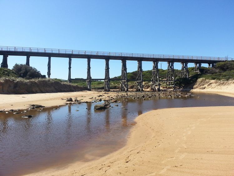
Trestle Bridge
The 91 m long Kilcunda Bridge was built over the Bourne Creek. It is protected by the National Trust. This trestle bridge was constructed for the Victorian Railways to carry coal from what was then known as the Powlett Coal Fields. It is a particularly significant monument because most of the steam-locomotive fuel that serviced the Victorian Railways network, from 1911 until 1978, crossed over this bridge. Since disused, the bridge is now a tourist attraction and a part of the Bass Coast Rail Trail. Bourne creek spills over Kilcunda Beach and out into the sea of Bass Strait. Seashell collecting is permitted on Kilcunda Beaches.
Kilcunda Ocean View Hotel
The Kilcunda Ocean View Hotel is located on the Bass Highway directly opposite Kilcunda Beach.
Bass Coast Rail Trail
Walking, cycling and horse trotting is the modern use of the old Wonthaggi railway line all year round. The Bass Coast Rail Trail is very flat and begins near Kilcunda at the roundabout to Phillip Island and ends at the Wonthaggi shopping district. You can also access it all along the way, including at Kilcunda. Victoria's only coastal rail trail, it stretches 16 kilometres from Anderson to Wonthaggi, meandering through farmland, coastal bushland, historic coal mining nature reserves and coastline with a clear view of the Wonthaggi wind turbines and remnants of coal mine buildings. The trail crosses over the Powlett River and the Bourne Creek trestle bridge at Kilcunda, which has panoramic views of the beach. Kangaroos can often be spotted as well as many bird species. An extension of the trail from Anderson to Woolamai, on Phillip Island, has not yet been made suitable for cyclists. Public toilets are situated at each town along the way. Public toilets in Anderson are situated at the bus interchange which handles connections between the San Remo and Inverloch/Wonthaggi public transport routes. The bus interchange is adjacent to the eastern side of the Anderson roundabout.
Kilcunda Lobster Festival
The Annual Kilcunda Lobster Festival began in 1984 and is held on Australia Day weekend.
Shore Fishing
Very popular surf fishing area, catching Salmon, Trout and Yellow-eyed Mullet.
Climate
Kilcunda's location on the north shore of Bass Strait gives it an oceanic climate, with the moderating effect of the ocean allowing a narrower temperature range throughout the year compared to other regions in Victoria. Average daily maximum temperatures range from 23.5 °C in the summer to 13.5 in winter. Frost is rare, occurring on average 6 mornings a year.
History
The Bunurong Aboriginal people were custodians of this stretch of coast for thousands of years prior to white settlement. The Boakoolawal clan lived in the Kilcunda area south of the Bass River. Middens containing charcoal and shellfish mark the location of their campsites along the coast.
Originally a coal mining township, The Western Port Coal Mining Company extracted black coal from 1871. The Post Office opened on 5 August 1879. Evidence of coal mining is scattered across Kilcunda, the most famous (pictured here) is the old Kilcunda Rail Bridge on the eastern side. Commissioned in 1910 and decommissioned in the 1970s, it now forms part of the Bass Coast Rail Trail. Mitchell's Black Coal Mine ruins are on Carew Road.
Education
There is a primary school in nearby San Remo, a primary school in nearby Dalyston and Wonthaggi has three primary schools and one secondary college. There is a private secondary college on nearby Phillip Island. Also Chisholm TAFE, Bass Coast Specialist School, Bass Coast Adult Education Centre, University of the Third Age (U3A) retirees education centre, and Connecting Skills Australia (CSA) specialist developmental school, support and employment services/training.
Plans are underway for a new tertiary education facility.